Approximate Location Map
Large Map »
Latitude: 53.4908 / 53°29'26"N
Longitude: -0.8727 / 0°52'21"W
OS Eastings: 474890
OS Northings: 399933
OS Grid: SK748999
Mapcode National: GBR QXB2.VC
Mapcode Global: WHFFJ.KJN7
Plus Code: 9C5XF4RG+8W
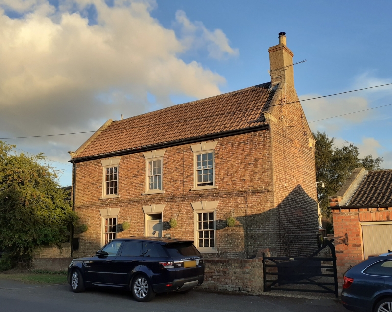
Entry Name: Park Farmhouse
Listing Date: 10 September 1987
Grade: II
Source: Historic England
Source ID: 1067710
English Heritage Legacy ID: 165187
ID on this website: 101067710
Location: Westwoodside, North Lincolnshire, DN9
County: North Lincolnshire
Civil Parish: Haxey
Built-Up Area: Westwoodside
Traditional County: Lincolnshire
Lieutenancy Area (Ceremonial County): Lincolnshire
Church of England Parish: Haxey St Nicholas
Church of England Diocese: Lincoln
Tagged with: Farmhouse
SK 79 NW HAXEY UPPERTHORPE ROAD
(south side)
Westwoodside
13/123 Park Farmhouse
- II
Wrongly marked as Upperthorpe Hill on Ordnance Survey map. Farmhouse, now
house. 1774, with later alterations. Brown brick, in Flemish bond to
front. Concrete tile roof. T-shaped on plan: 2-room, central entrance-hall
north front with 2-room wing and single-room addition to rear. 2 storeys, 3
bays; symmetrical. Plain C20 door and plain overlight beneath keyed stucco
flat arch, flanked by C19 four-pane sashes in original flush wooden
architraves with sills beneath similar arches. 3-course first-floor band
with upper course projecting. Similar first-floor sashes in similar
surrounds. Dentilled brick eaves cornice, obscured by C20 wooden eaves
board. Stone-coped gables with shaped kneelers. Corniced end stack to
right; end stack to left removed. Gable ends have wrought-iron initials
"W E" to left, and figures "7 4" to right. Right return, rear wing, has 12-
pane sliding sash to ground floor beneath segmental arch, unequal 9-pane
first-floor sashes with lintels at eaves level. Left return has
unsympathetic C20 casements to front range and rear wing, 2-pane sliding
sash to single-storey single-window rear addition. Rear wing has stepped
and dentilled brick eaves cornice, stone-coped gable with shaped kneeler,
end stack. Interior: open-well staircase with ramped moulded handrail,
balustrade boxed-in: not fully investigated. Empty and unoccupied at time
of resurvey.
Listing NGR: SK7489099933
External links are from the relevant listing authority and, where applicable, Wikidata. Wikidata IDs may be related buildings as well as this specific building. If you want to add or update a link, you will need to do so by editing the Wikidata entry.


Other nearby listed buildings
