Approximate Location Map
Large Map »
Latitude: 53.6403 / 53°38'25"N
Longitude: -0.7816 / 0°46'53"W
OS Eastings: 480648
OS Northings: 416668
OS Grid: SE806166
Mapcode National: GBR QVZB.LS
Mapcode Global: WHFDS.YRZM
Plus Code: 9C5XJ6R9+49
Entry Name: The Old Vicarage Including Adjoining Carriage House and Stables
Listing Date: 30 September 1987
Grade: II
Source: Historic England
Source ID: 1346764
English Heritage Legacy ID: 165386
ID on this website: 101346764
Location: Eastoft, North Lincolnshire, DN17
County: North Lincolnshire
Civil Parish: Eastoft
Built-Up Area: Eastoft
Traditional County: Yorkshire
Lieutenancy Area (Ceremonial County): Lincolnshire
Church of England Parish: Eastoft St Bartholomew
Church of England Diocese: Sheffield
Tagged with: Clergy house
SE 81 NW EASTOFT HIGH STREET
(west side)
4/6 The Old Vicarage
including adjoining
carriage house and
stables
GV II
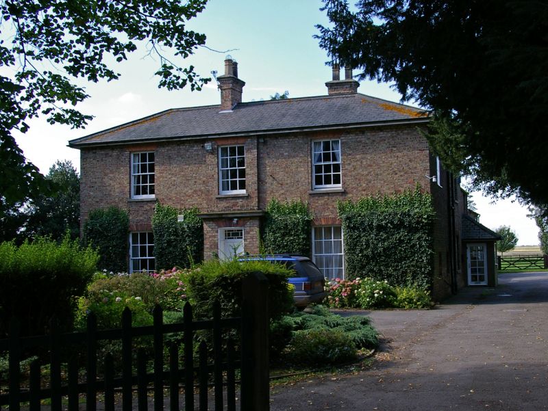
Parsonage house, now house, with adjoining carriage house and stables. Mid
C19, probably 1855, by J L Pearson. Light brown brick in Flemish bond with
rubbed red brick and sandstone ashlar dressings. Welsh slate roof. L-
shaped on plan: double-depth house with 3-room, central entrance-hall east
front, drawing room and dining room to rear, kitchen wing to rear right with
carriage house/stable and stores range beyond. East front: 2 storeys, 3
bays; symmetrical, with central bay breaking forward. Chamfered brick
plinth. Steps to panelled door beneath moulded lintel and overlight with
geometric glazing bars and coloured margin lights in panelled reveal beneath
flat red brick arch and moulded ashlar cornice; first-floor section stepped-
in above. 12-pane ground-floor sashes in reveals with projecting stone
sills beneath red brick cambered arches. Similar but slightly shorter
first-floor sashes. Deep eaves. Hipped roof. Ridge stack with brick band,
ashlar cornice and octagonal pots. Similar stacks to rear and right return.
Left return forms garden front: 2 bays, with recessed left bay. Right bay
has central section breaking forward, with 12-pane sash beneath brick
cambered arch and ashlar cornice, narrower raised section above with 12-pane
first-floor sash below similar arch. Left bay has wooden ground-floor
canted bay window with French windows and overlight with glazing bars to
front, and unequal 10-pane sashes to sides, in Doric surround with tapered
pilasters carrying entablature with triglyphs, guttae, moulded cornice,
blocking course and flat hood. Central first-floor section above breaks
forward with 12-pane sash, narrow 8-pane sash in angle to right, both below
cambered brick arches. Right return has irregular fenestration with hung
and sliding sashes with glazing bars beneath brick cambered arches. Coped
wall with round-headed opening links rear wing to carriage house/stables and
stores range. 2-storey section to left, with 2 first-floor openings, has
basket-arched carriage entrance to right with 2-fold board doors, pair of
board doors and 12-pane sliding sash to left beneath segmental arches;
first-floor hatch to right with board door beneath segmental arch, blocked
similar opening to left, stepped eaves, ridge stack. Single-storey section
to right has sliding sash and pair of board doors beneath segmental arches,
coped right gable. Interior of house: original features include open-well
staircase with ramped grip handrail, turned newel posts, plain balusters and
inserted C20 wrought-iron balusters, profiled cheek-pieces; marble chimney-
pieces to 2 ground-floor front rooms, one with carved consoles; moulded
plaster cornices, panelled window shutters, 6-pane doors in architraves
beneath moulded cornices. Probably built together with the neighbouring
church of St Bartholomew (qv) and school in 1855.
Listing NGR: SE8064816668
External links are from the relevant listing authority and, where applicable, Wikidata. Wikidata IDs may be related buildings as well as this specific building. If you want to add or update a link, you will need to do so by editing the Wikidata entry.


Other nearby listed buildings
