Approximate Location Map
Large Map »
Latitude: 53.6478 / 53°38'52"N
Longitude: -0.3446 / 0°20'40"W
OS Eastings: 509519
OS Northings: 418088
OS Grid: TA095180
Mapcode National: GBR VV18.52
Mapcode Global: WHGG4.PK3V
Plus Code: 9C5XJMX4+45
Entry Name: Stables Approximately 60 Metres East of Thornton Hall
Listing Date: 6 November 1967
Grade: II
Source: Historic England
Source ID: 1227843
English Heritage Legacy ID: 165888
ID on this website: 101227843
Location: North Lincolnshire, DN39
County: North Lincolnshire
Civil Parish: Thornton Curtis
Traditional County: Lincolnshire
Lieutenancy Area (Ceremonial County): Lincolnshire
Church of England Parish: Thornton Curtis St Lawrence
Church of England Diocese: Lincoln
Tagged with: Stable
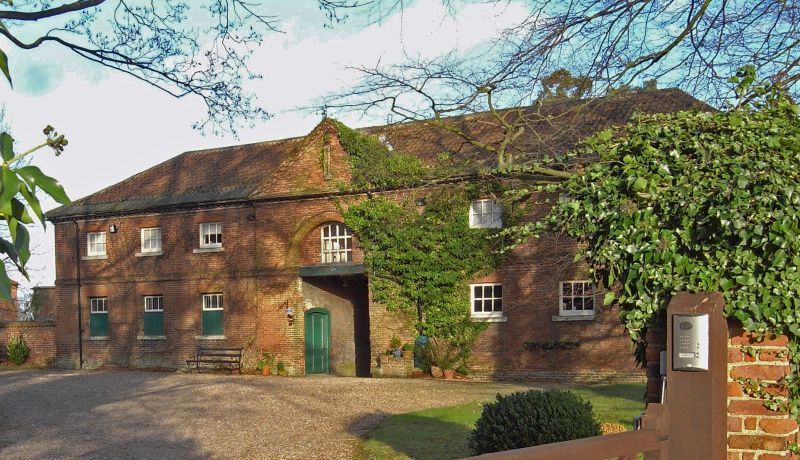
TA 01 NE THORNTON CURTIS STATION ROAD
(north side)
9/87 Stables approximately 60
metres east of Thornton
6.11.67 Hall
GV II
Stables/granary and house adjoining to right. 1760s, probably by John
Billington, with later alterations and additions to rear. Red brick in
Flemish bond. Pantile roof. U-shaped on plan, with house to rear right.
West front, facing Hall: 2 storeys, 7 bays with central pedimented bay
breaking forward. Moulded plinth. Central carriage entrance has 8-pane
overlight (doors removed) beneath recessed round-headed panel with 12-pane
casement and brick hoodmould continued either side as first floor band.
3 recessed part-glazed hatches to left with 2-fold doors beneath 3-panes;
two 6-pane casements to right end. 3-course brick first floor band with
ovolo-moulded top course. 6-pane first floor casements. All windows with
rubbed brick flat arches and stucco cills. Stepped and dentilled brick
eaves cornice, with raking cornice and stone-coped gable to pediment. Right
return, facing road, has plinth, pilaster strips and brick eaves cornice;
2 low storey house section to right in matching style and materials with
16-pane recessed sashes under segmental arches, axial and end stacks.
N Pevsner and J Harris, The Buildings of England: Lincolnshire, 1978, 405.
Listing NGR: TA0951918088
External links are from the relevant listing authority and, where applicable, Wikidata. Wikidata IDs may be related buildings as well as this specific building. If you want to add or update a link, you will need to do so by editing the Wikidata entry.


Other nearby listed buildings
