Approximate Location Map
Large Map »
Latitude: 53.7088 / 53°42'31"N
Longitude: -0.2269 / 0°13'36"W
OS Eastings: 517132
OS Northings: 425056
OS Grid: TA171250
Mapcode National: GBR VTVK.P7
Mapcode Global: WHHH4.H16L
Plus Code: 9C5XPQ5F+G7
Entry Name: Thorngumbald Clough Low Lighthouse
Listing Date: 21 May 1987
Grade: II
Source: Historic England
Source ID: 1083435
English Heritage Legacy ID: 166658
Also known as: Thorngumbald Clough Low Light
ID on this website: 101083435
Location: East Riding of Yorkshire, HU12
County: East Riding of Yorkshire
Civil Parish: Paull
Traditional County: Yorkshire
Lieutenancy Area (Ceremonial County): East Riding of Yorkshire
Church of England Parish: Paull St Andrew and St Mary
Church of England Diocese: York
Tagged with: Lighthouse
PAULL THORNGUMBALD ROAD
TA 12 NE
(south-west side, off)
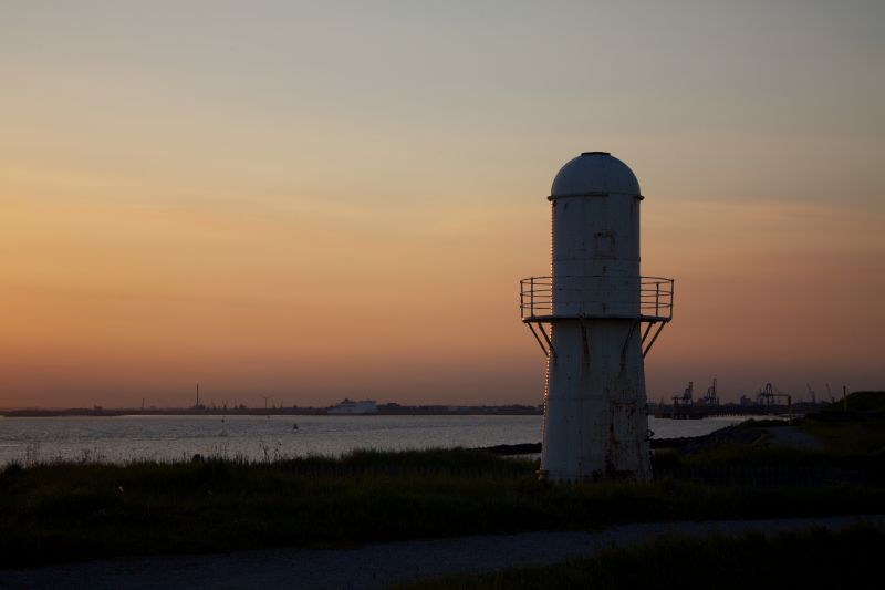
3/12 Thorngumbald Clough Low
Lighthouse
GV II
Lighthouse. 1870 for Trinity House; later attached to base. Brick and
flagstone base with iron rails carrying tower with rivetted wrought-iron
frame, casing and balcony; painted white. Base rectangular on plan,
approximately 2 metres high, with flagstone top carrying pair of rails on
bolted brackets. Flight of wooden steps up to lighthouse door on south
side. Lighthouse: tapered round tower, of 2 stages, approximately 10 metres
high, with square concrete plinth fixing it to base. First stage has low
door with strap hinges, projecting rectangular window above. Upper stage
has angle struts supporting cast-iron balcony with plain railings, small -
door with strap hinges, and small projecting square window above, large -
projecting square window to north. Gutter, domed cap with cylindrical
ventilator. An unusual and innovative design; the tower originally moved to
establish a new line for approaching vessels to follow between Paull and The
Hebbles. One of the series of Humber Estuary Lights which included
lighthouses at Spurn Point, Easington parish (qv), and South Killingholme
(qv) on the south bank. Together with the neighbouring High Lighthouse to
the south (qv), and others at Salt End (now removed), it replaced the
lighthouse at Town End Road, Paull (qv). Still in operation. D Jackson,
Lighthouses of England and Wales, 1975, p l05.
Listing NGR: TA1713225056
External links are from the relevant listing authority and, where applicable, Wikidata. Wikidata IDs may be related buildings as well as this specific building. If you want to add or update a link, you will need to do so by editing the Wikidata entry.


Other nearby listed buildings
