Approximate Location Map
Large Map »
Latitude: 53.837 / 53°50'13"N
Longitude: -0.4502 / 0°27'0"W
OS Eastings: 502084
OS Northings: 438978
OS Grid: TA020389
Mapcode National: GBR TS92.B8
Mapcode Global: WHGF4.1TXB
Plus Code: 9C5XRGPX+RW
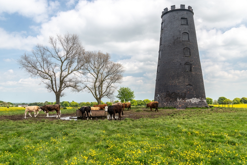
Entry Name: The Black Mill
Listing Date: 30 June 1987
Grade: II
Source: Historic England
Source ID: 1310087
English Heritage Legacy ID: 167224
ID on this website: 101310087
Location: East Riding of Yorkshire, HU17
County: East Riding of Yorkshire
Civil Parish: Beverley
Traditional County: Yorkshire
Lieutenancy Area (Ceremonial County): East Riding of Yorkshire
Church of England Parish: Beverley Minster St John and St Martin
Church of England Diocese: York
Tagged with: Mill building
TA 0238 BEVERLEY KELDGATE ROAD
(north side)
12/124 The Black Mill
II
Stump of an early C19 windmill, tarred brick, 5 storeys, the top now crenellated.
Listing NGR: TA0208438978
External links are from the relevant listing authority and, where applicable, Wikidata. Wikidata IDs may be related buildings as well as this specific building. If you want to add or update a link, you will need to do so by editing the Wikidata entry.


Other nearby listed buildings
