Approximate Location Map
Large Map »
Latitude: 53.8406 / 53°50'26"N
Longitude: -0.4316 / 0°25'53"W
OS Eastings: 503298
OS Northings: 439400
OS Grid: TA032394
Mapcode National: GBR TSF1.C0
Mapcode Global: WHGF4.BQQL
Plus Code: 9C5XRHR9+69
Entry Name: 80, Lairgate
Listing Date: 2 July 1969
Grade: II
Source: Historic England
Source ID: 1084019
English Heritage Legacy ID: 167263
ID on this website: 101084019
Location: Beverley, East Riding of Yorkshire, HU17
County: East Riding of Yorkshire
Civil Parish: Beverley
Built-Up Area: Beverley
Traditional County: Yorkshire
Lieutenancy Area (Ceremonial County): East Riding of Yorkshire
Church of England Parish: Beverley Minster St John and St Martin
Church of England Diocese: York
Tagged with: Building
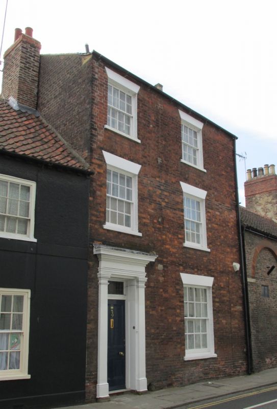
TA 0339 BEVERLEY LAIRGATE
(west side)
8/162 No 80
9/162
2.7.69
GV II
Early C19. Three storeys in red brick with slate roof. Eaves soffit with
widely spaced block brackets. Two windows, hung sashes with glazing bars,
stuccoed flat arches. Door of 4 fielded panels, fanlight, doorcase with
pilasters and entablature.
Listing NGR: TA0329839400
External links are from the relevant listing authority and, where applicable, Wikidata. Wikidata IDs may be related buildings as well as this specific building. If you want to add or update a link, you will need to do so by editing the Wikidata entry.


Other nearby listed buildings
