Approximate Location Map
Large Map »
Latitude: 51.1124 / 51°6'44"N
Longitude: 0.4584 / 0°27'30"E
OS Eastings: 572180
OS Northings: 137666
OS Grid: TQ721376
Mapcode National: GBR PT2.2QZ
Mapcode Global: VHJN4.W9QK
Plus Code: 9F324F65+X9
Entry Name: Outbuilding About 5 Metres South of Hughenden
Listing Date: 22 June 1989
Grade: II
Source: Historic England
Source ID: 1084655
English Heritage Legacy ID: 169593
ID on this website: 101084655
Location: Goudhurst, Tunbridge Wells, Kent, TN17
County: Kent
District: Tunbridge Wells
Civil Parish: Goudhurst
Built-Up Area: Goudhurst
Traditional County: Kent
Lieutenancy Area (Ceremonial County): Kent
Tagged with: Appendage
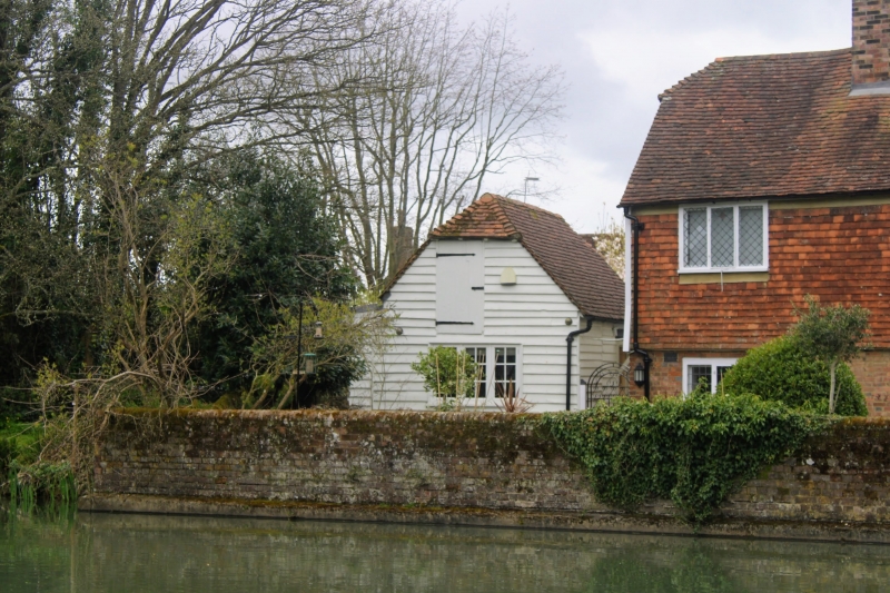
GOUDHURST THE PLAIN
TQ 7237-7337 (west side)
15/243
Outbuilding about
5 metres south of
Hughenden
GV II
Stable/outbuilding. C18. Timber framed and weather boarded with plain tiled
roof. One storey and loft with half hipped roof. Boarded loft doors in gable
ends. Boarded doors and wooden casements. A ground floor, and wooden casement
in gable end. Included for group value.
Listing NGR: TQ7218037666
External links are from the relevant listing authority and, where applicable, Wikidata. Wikidata IDs may be related buildings as well as this specific building. If you want to add or update a link, you will need to do so by editing the Wikidata entry.


Other nearby listed buildings
