Approximate Location Map
Large Map »
Latitude: 51.2801 / 51°16'48"N
Longitude: 1.0791 / 1°4'44"E
OS Eastings: 614837
OS Northings: 157939
OS Grid: TR148579
Mapcode National: GBR TY2.PN9
Mapcode Global: VHLGM.N3B1
Plus Code: 9F3373JH+2J
Entry Name: 11, Best Lane
Listing Date: 7 September 1973
Grade: II
Source: Historic England
Source ID: 1248724
English Heritage Legacy ID: 170382
ID on this website: 101248724
Location: Canterbury, Kent, CT1
County: Kent
District: Canterbury
Electoral Ward/Division: Westgate
Parish: Non Civil Parish
Built-Up Area: Canterbury
Traditional County: Kent
Lieutenancy Area (Ceremonial County): Kent
Tagged with: Building
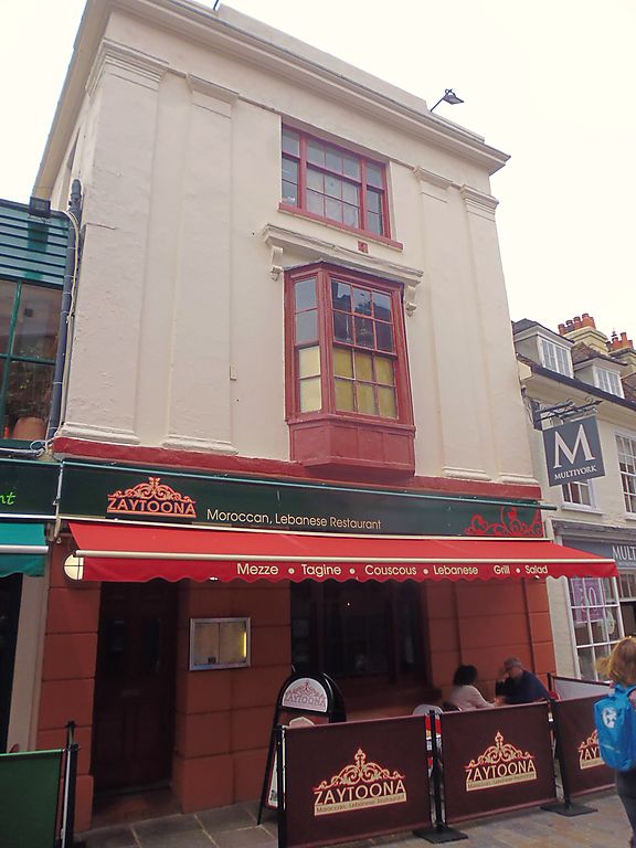
1.
944 BEST LANE
(North West Side)
TR 1457 NE 4/410 No 11
II GV
2.
Early C19 facade. 3 storeys and basement stuccoed. Parapet with stone coping.
Dropped moulded modillion cornice. 4 plain pilasters from third to first
floor. 1 sash with glazing bars intact, 3 light on second floor, canted
bay on first floor. Rusticated base. Left side doorcase with recessed fanlight
and door.
Nos 3 to 12 (consec) form a group.
Listing NGR: TR1485857959
External links are from the relevant listing authority and, where applicable, Wikidata. Wikidata IDs may be related buildings as well as this specific building. If you want to add or update a link, you will need to do so by editing the Wikidata entry.


Other nearby listed buildings
