Approximate Location Map
Large Map »
Latitude: 51.2769 / 51°16'36"N
Longitude: 1.0771 / 1°4'37"E
OS Eastings: 614713
OS Northings: 157584
OS Grid: TR147575
Mapcode National: GBR TY2.WP7
Mapcode Global: VHLGM.M59F
Plus Code: 9F3373GG+QV
Entry Name: 12-14, Castle Street
Listing Date: 3 May 1967
Grade: II
Source: Historic England
Source ID: 1085092
English Heritage Legacy ID: 170495
ID on this website: 101085092
Location: Canterbury, Kent, CT1
County: Kent
District: Canterbury
Electoral Ward/Division: Westgate
Parish: Non Civil Parish
Built-Up Area: Canterbury
Traditional County: Kent
Lieutenancy Area (Ceremonial County): Kent
Tagged with: Building
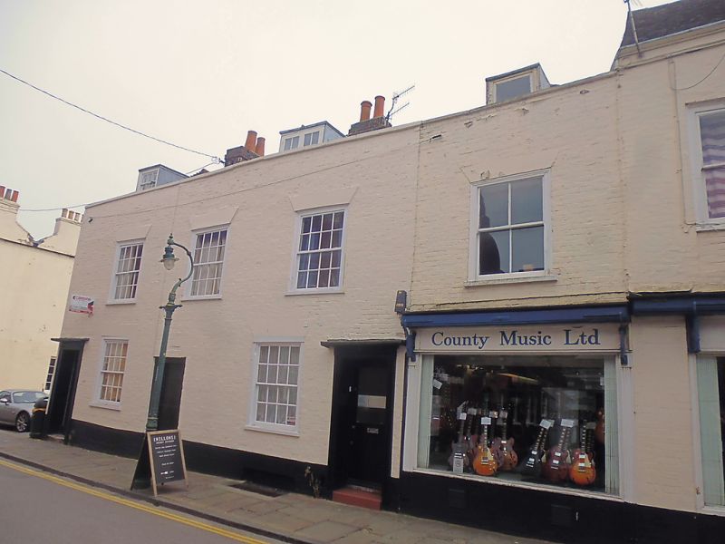
1.
944 CASTLE STREET
(South East Side)
Nos 12 to 14 (consec)
TR 1457 NE 4/259 3.5.67.
II GV
2.
Early C18 refaced in early C19. 2 storeys brick with stone coping. Roof
in 3 hips with 3 dormers. 4 sashes with glazing bars intact except to No
14. No 14 has a later C19 shopfront. 3 simple doorcases, 2 having 6 panelled
doors. Footscrapers. Plinth.
Nos 1 to 9 (consec) and Nos 12 to 24 (consec) form a group.
Listing NGR: TR1471657584
External links are from the relevant listing authority and, where applicable, Wikidata. Wikidata IDs may be related buildings as well as this specific building. If you want to add or update a link, you will need to do so by editing the Wikidata entry.


Other nearby listed buildings
