Approximate Location Map
Large Map »
Latitude: 51.2072 / 51°12'25"N
Longitude: 1.1576 / 1°9'27"E
OS Eastings: 620654
OS Northings: 150073
OS Grid: TR206500
Mapcode National: GBR TZ4.CGK
Mapcode Global: VHLGW.0XTF
Plus Code: 9F336545+V2
Entry Name: Bridge Cottage
Listing Date: 14 March 1980
Grade: II
Source: Historic England
Source ID: 1111850
English Heritage Legacy ID: 170949
ID on this website: 101111850
Location: Barham, Canterbury, Kent, CT4
County: Kent
District: Canterbury
Civil Parish: Barham
Built-Up Area: Barham
Traditional County: Kent
Lieutenancy Area (Ceremonial County): Kent
Tagged with: Cottage
1.
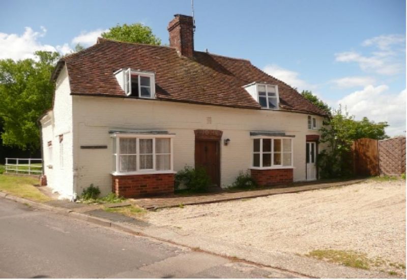
5273 BARHAM THE STREET
(north side)
Bridge Cottage
TR 2050 24/73
II GV
2.
Plaque over door reads 1725 S J. Two storeys in painted brick with half-hipped
tile roof and centre brick stack. Two dormers at eaves. Two square C19 bays
on ground floor and plain door with brick header segmental head. Penticed
extension to right in painted knapped flint, one window over door.
Listing NGR: TR2065450073
External links are from the relevant listing authority and, where applicable, Wikidata. Wikidata IDs may be related buildings as well as this specific building. If you want to add or update a link, you will need to do so by editing the Wikidata entry.


Other nearby listed buildings
