Approximate Location Map
Large Map »
Latitude: 51.3304 / 51°19'49"N
Longitude: 1.4147 / 1°24'53"E
OS Eastings: 637977
OS Northings: 164573
OS Grid: TR379645
Mapcode National: GBR X0L.JJ4
Mapcode Global: VHMCW.GTSG
Plus Code: 9F338CJ7+5V
Entry Name: 49, Addington Street
Listing Date: 13 June 1986
Grade: II
Source: Historic England
Source ID: 1336630
English Heritage Legacy ID: 171657
ID on this website: 101336630
Location: Ramsgate, Thanet, Kent, CT11
County: Kent
District: Thanet
Civil Parish: Ramsgate
Built-Up Area: Ramsgate
Traditional County: Kent
Lieutenancy Area (Ceremonial County): Kent
Tagged with: Building
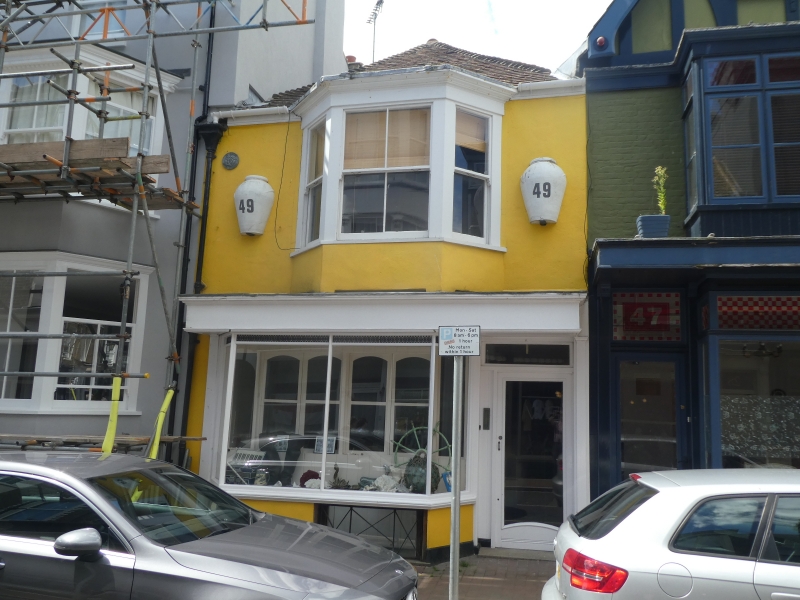
RAMSGATE ADDINGTON STREET
TR 3764 NE
(west side)
12/28 No. 49
13.6.86
GV II
House and shop. Early C18 or earlier, altered 1801-21 and late C19. Brick
and flint, rendered on front elevation with plain tiled roof. Two storeys
and basement with parapet to hipped roof with stacks to rear. Canted bay/
oriel on first floor and canted plate glass later C19 shop front on ground
floor, with traceried basement opening below and plate glass door to right
all under cornice fascia on pilasters. The shop front mouldings show late
C19 Arts and Crafts style influences. Interior: cellar lined with red brick
in English and irregular bond, and with flint and large dressed stone blocks.
Remains of stair with turned newels, winder plan. C19 beaded boarded
panelling with moulded skirting and cornice. Queen strut roof. The building
is all that survives substantially of the farming and fishing hamlet which
occupied this site before the development of Addington Street after 1801 by
James Townley, and the adjacent Cavalry Barracks, and incorporates in the
basement remains of what may be late medieval buildings. (See Collard and
Hurst's plan of Ramsgate, 1821; see also C. Busson, Ramsgate, pp. 118.9).
Listing NGR: TR3797764573
External links are from the relevant listing authority and, where applicable, Wikidata. Wikidata IDs may be related buildings as well as this specific building. If you want to add or update a link, you will need to do so by editing the Wikidata entry.


Other nearby listed buildings
