Approximate Location Map
Large Map »
Latitude: 51.3359 / 51°20'9"N
Longitude: 1.4044 / 1°24'15"E
OS Eastings: 637229
OS Northings: 165148
OS Grid: TR372651
Mapcode National: GBR X0L.1XG
Mapcode Global: VHMCW.9P98
Plus Code: 9F338CP3+9Q
Entry Name: 2 and 4, Ashburnham Road
Listing Date: 4 February 1988
Grade: II
Source: Historic England
Source ID: 1336654
English Heritage Legacy ID: 171679
ID on this website: 101336654
Location: Nethercourt, Thanet, Kent, CT11
County: Kent
District: Thanet
Civil Parish: Ramsgate
Built-Up Area: Ramsgate
Traditional County: Kent
Lieutenancy Area (Ceremonial County): Kent
Tagged with: Building
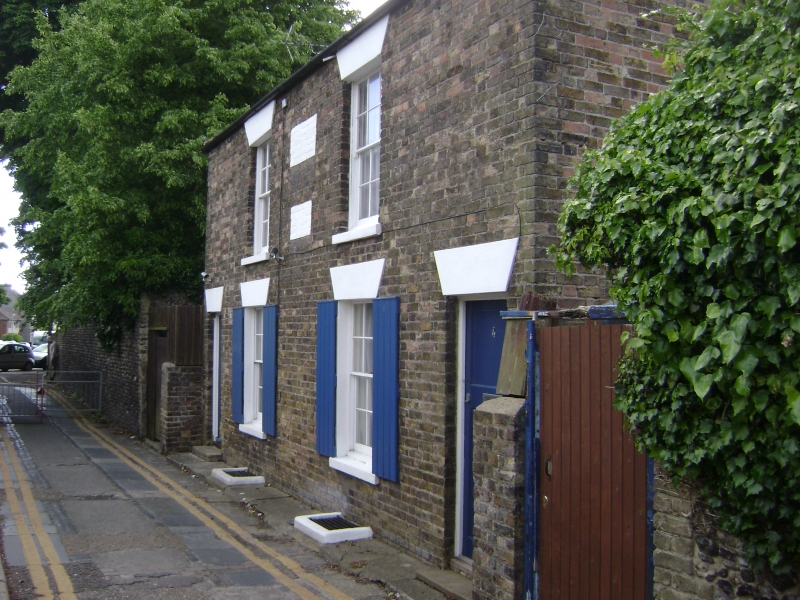
RAMSGATE ASHBURNHAM ROAD
TR 3765 SW
(south side)
7/50 Nos. 2 and 4
GV II
Cottage pair. 1840's. Stock brick and tiled roof. Two storeys with hipped
roof and central stack. Regular fenestration of 2 glazing bar sashes on
each floor, with painted heads and shutters on ground floor. Door of 2
panels to left, and half-glazed door to right. Name plaques to centre
painted over and illegible. Included for group value.
Listing NGR: TR3722965148
External links are from the relevant listing authority and, where applicable, Wikidata. Wikidata IDs may be related buildings as well as this specific building. If you want to add or update a link, you will need to do so by editing the Wikidata entry.


Other nearby listed buildings
