Approximate Location Map
Large Map »
Latitude: 51.3353 / 51°20'7"N
Longitude: 1.4238 / 1°25'25"E
OS Eastings: 638582
OS Northings: 165146
OS Grid: TR385651
Mapcode National: GBR X0M.6S8
Mapcode Global: VHMCW.MPKQ
Plus Code: 9F338CPF+4G
Entry Name: 22 Bellevue Road and railed area
Listing Date: 13 September 1974
Last Amended: 22 May 2019
Grade: II
Source: Historic England
Source ID: 1099103
English Heritage Legacy ID: 171688
ID on this website: 101099103
Location: Ramsgate, Thanet, Kent, CT11
County: Kent
District: Thanet
Civil Parish: Ramsgate
Built-Up Area: Ramsgate
Traditional County: Kent
Lieutenancy Area (Ceremonial County): Kent
Tagged with: Building
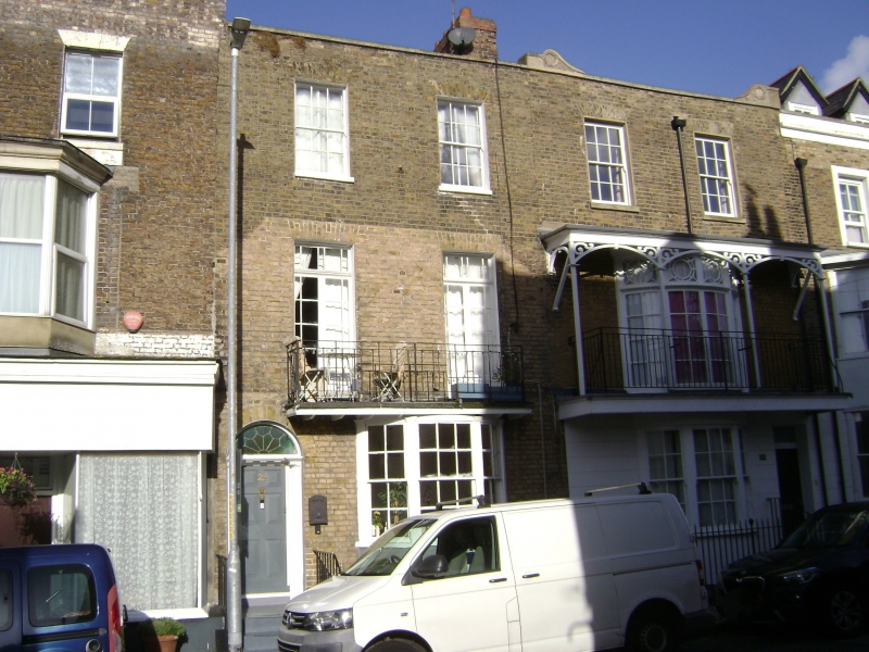
A terraced town-house of around 1830.
A terraced town-house of around 1830.
MATERIALS and PLAN: stock brick in Flemish bond. Formed of three storeys, above a lit basement, which has its own entrance from the street.
EXTERIOR: the road front, facing east, is formed of two bays and is Georgian in style. On the ground floor, the main entrance is to the south-side and at the head of a flight of three stone steps. It has a six-panelled door with a rounded fanlight above, which has later-C20 glass. The door case has fluted quarter-columns, supporting an architrave with a dentil moulding. To the north-side there is a bow window, which projects in front of the line of the basement wall, with three, curved-sashes of six-over-six panes, delineated by Ionic pilasters. The basement window is recessed below the bow, and has a sash window of six-over-six panes. The basement is accessed by stone steps from the street level. The first floor has a pair of French windows which are multi-paned, and have margin glazing. They front on to a balcony with simple rails of C20 date. The outline of the balcony canopy which was formerly attached to the front can be seen, with its ramped profile. The third floor has two sash windows with six-over-six panes. The upper-floor windows all have flat, gauged-brick headers. There is a stone parapet, and the roof is hidden behind.
INTERIOR: not inspected.
SUBSIDIARY FEATURES: there are metal railings with simple rails and four baluster finials, which stretch from the main entrance (via three stone steps) to the top of the basement stair (via a rail-gate).
The 1822 Collard and Hurst map of Ramsgate shows Bellevue Road populated with a small number of buildings, but it is not possible to determine whether they include 22 Bellevue Road. The 1842 edition of the Ordnance Survey map shows buildings all along Bellevue Road. As such, 22 Bellevue Road probably dates from around 1830. In the C20, the balcony canopy was removed, and the balcony replaced.
Ramsgate is situated on the east coast of the Isle of Thanet, facing France and the Low Countries. Originating as a fishing village within the medieval parish of St Laurence, Ramsgate’s development from the C16 was driven by the strategic importance of its coastal port. Ramsgate became associated with the Cinque Ports as a limb of Sandwich from the C14. Late C17 trade with Russia and the Baltic resulted in a wave of investment and rebuilding in the town. In 1749 the construction of a harbour of refuge from storms in the North Sea and Channel was approved, and a cross wall and inner basin were completed in 1779 to the design of John Smeaton. Later improvements included a lighthouse of 1794-1795 by Samuel Wyatt and a clock house of 1817 by Wyatt and George Louch.
From the mid-C18 Ramsgate became increasingly popular as a seaside resort, its expansion being accelerated by road improvements and faster sea passage offered by hoys, packets and steamers. An assembly room, warm water baths, subscription libraries and places of worship were joined by new streets such as Effingham Street and speculative crescents and squares on the East and West Cliffs such as Albion Place of around1791-1798 and Nelson Crescent of around 1800-1805. During the Napoleonic Wars Ramsgate became a busy garrison town and a major port of embarkation. Ramsgate’s importance in the 1820s is attested by its patronage by the British and European royal families and the creation of a separate parish by Act of Parliament, served by the large Church of St George (1824-1827). The harbour is the only one in the British Isles which has the designation ‘Royal’, granted by George IV.
The arrival of the South Eastern Railway’s branch line in 1846 opened up Ramsgate to mass tourism and popular culture, bringing a range of inexpensive, lively resort facilities intended for the sorts of middle and working-class holidaymakers depicted in W P Frith’s painting ‘Ramsgate Sands’ of 1854 (Royal Collection). Wealthier visitors were accommodated at a respectable distance from the town in developments such as E W Pugin’s Granville Hotel of 1867-1869. Competition with other Kentish resorts stimulated a series of large-scale improvements in the late C19 and early C20 including the construction of Royal Parade and landscaped stairs and pathways at the eastern and western ends of the seafront to join the upper promenades to the Undercliff walks. New schools, hospitals and services were also built. The thriving town attracted diverse faith communities; Moses Montefiore founded a synagogue and a religious college at East Cliff Lodge, while A W N Pugin St Augustine’s Church and the Grange as part of an intended Catholic community on the West Cliff.
In 1940 the harbour was the point of return for many of the small boats involved in the evacuation from Dunkirk and war-time precautions included the digging of extensive air raid shelter tunnels in the chalk beneath the town. Ramsgate remained a popular holiday destination until the advent of cheap foreign travel in the post-war decades. Falling visitor numbers were exacerbated by the decline of the town’s small trades and industries, fishing and boat-building. However, a ferry and hovercraft port and the large marina created in the inner harbour in the 1970s have continued to bring life to the area.
22 Bellevue Road, a terraced town-house of around 1830, is listed at Grade II for the following principal reasons:
Architectural interest:
* it is a good example of an early-C19 Georgian town house;
* although the balcony canopy has been removed, the remainder of the architectural detailing is largely intact, including the street railings.
Historic interest:
* as an example of speculative development in Ramsgate during the early C19, driven by its Royal patronage, and selection as an embarkation port for the Napoleonic Wars.
Group value:
* as part of the architectural and historic unity of early-C19 town-houses in Bellevue Road
External links are from the relevant listing authority and, where applicable, Wikidata. Wikidata IDs may be related buildings as well as this specific building. If you want to add or update a link, you will need to do so by editing the Wikidata entry.


Other nearby listed buildings
