Approximate Location Map
Large Map »
Latitude: 51.3335 / 51°20'0"N
Longitude: 1.4201 / 1°25'12"E
OS Eastings: 638331
OS Northings: 164934
OS Grid: TR383649
Mapcode National: GBR X0L.CV0
Mapcode Global: VHMCW.KRL3
Plus Code: 9F338CMC+C2
Entry Name: The Red Lion
Listing Date: 13 September 1974
Grade: II
Source: Historic England
Source ID: 1085339
English Heritage Legacy ID: 171869
ID on this website: 101085339
Location: Ramsgate, Thanet, Kent, CT11
County: Kent
District: Thanet
Civil Parish: Ramsgate
Built-Up Area: Ramsgate
Traditional County: Kent
Lieutenancy Area (Ceremonial County): Kent
Tagged with: Pub
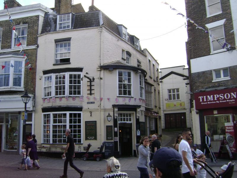
RAMSGATE KING STREET
TR 3864 NW
(south-east side)
13/236 No. 1 (The
Red Lion)
13.9.74
GV II
Public house. Late C17, altered C18 and early C19. Painted brick
with slate roof. Three storeys and attic with moulded string course
parapet to Mansard roof with 2 stacks to left. Single flat roofed
dormer to front elevation, and 2 to right return. Window opening,
boarded up, on 2nd floor, with 2 storey shallow canted bay below with
cornices on each floor, with 3 boarded openings at each floor. Tiled
base. Two storey bow to corner with boxed eaves, with 2 boarded
window openings on 1st floor, and double half-glazed doors with
rectangular fanlight and bracketted cornice and iron lamp on plain
bracket. Right return with 2 blocks, with 2 glazing bar sashes and
3 glazing bar sashes on upper floor, and 2 to ground floor to rear
block, with triple pilastered doorway, boarded up, to left (front block).
All boarded window openings originally glazing bar sashes. Interior:
gutted by fire at time of survey. The public house was existing in
1717 when it was used as the meeting place of the sessions of the officers
of the Vill of Ramsgate (until the first Market House was built in 1785).
(See Busson, Ramsgate, 97; see also Mirams, Old Ramsgate Pubs, II.
Marked as Red Lion on Collard and Hurst's 1822 map).
Listing NGR: TR3833164934
External links are from the relevant listing authority and, where applicable, Wikidata. Wikidata IDs may be related buildings as well as this specific building. If you want to add or update a link, you will need to do so by editing the Wikidata entry.


Other nearby listed buildings
