Approximate Location Map
Large Map »
Latitude: 51.3348 / 51°20'5"N
Longitude: 1.4238 / 1°25'25"E
OS Eastings: 638583
OS Northings: 165084
OS Grid: TR385650
Mapcode National: GBR X0M.6SH
Mapcode Global: VHMCW.MQK4
Plus Code: 9F338CMF+WG
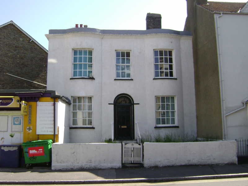
Entry Name: Admiral House
Listing Date: 4 February 1988
Grade: II
Source: Historic England
Source ID: 1336686
English Heritage Legacy ID: 171959
ID on this website: 101336686
Location: Ramsgate, Thanet, Kent, CT11
County: Kent
District: Thanet
Civil Parish: Ramsgate
Built-Up Area: Ramsgate
Traditional County: Kent
Lieutenancy Area (Ceremonial County): Kent
Tagged with: House
RAMSGATE THE PLAINS OF
TR 3865 SE
WATERLOO
(east side)
10/332 No. 50
(Admiral House)
GV II
House. Circa 1818. Roughcast with slate roof. Two storeys with cornice
and parapet to roof with stacks to left and to right. Two full height
shallow bows, with 3 glazing bar sashes on first floor and 2 on ground
floor, and central panelled door with semi-circular fanlight in double
rebated surround and with flight of 4 steps. Shown on Collard and Hurst's
1822 map of Ramsgate.
Listing NGR: TR3858365084
External links are from the relevant listing authority and, where applicable, Wikidata. Wikidata IDs may be related buildings as well as this specific building. If you want to add or update a link, you will need to do so by editing the Wikidata entry.


Other nearby listed buildings
