Approximate Location Map
Large Map »
Latitude: 51.3293 / 51°19'45"N
Longitude: 1.4138 / 1°24'49"E
OS Eastings: 637918
OS Northings: 164449
OS Grid: TR379644
Mapcode National: GBR X0L.Q7R
Mapcode Global: VHMCW.GV99
Plus Code: 9F338CH7+PG
Entry Name: Gate and Gatepiers About 20 Metres West of Nos 1 and 2
Listing Date: 4 February 1988
Grade: II
Source: Historic England
Source ID: 1203426
English Heritage Legacy ID: 172012
ID on this website: 101203426
Location: Ramsgate, Thanet, Kent, CT11
County: Kent
District: Thanet
Civil Parish: Ramsgate
Built-Up Area: Ramsgate
Traditional County: Kent
Lieutenancy Area (Ceremonial County): Kent
Tagged with: Gate
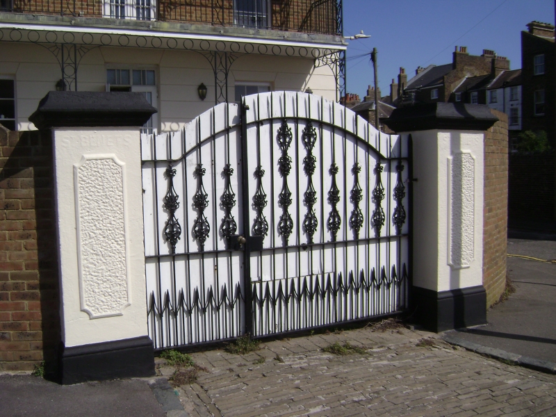
RAMSGATE SPENCER SQUARE
TR 3764 SE
(south side)
18/376 Gate and gatepiers
about 20 metres
west of Nos. 1 and 2
GV II
Gate and gate piers. late C19. Rendered piers with vermiculated panels
and cornice. Central iron gate with spiked rails. Of a design with the
house (St. Benet's) and included for group value.
Listing NGR: TR3791864449
External links are from the relevant listing authority and, where applicable, Wikidata. Wikidata IDs may be related buildings as well as this specific building. If you want to add or update a link, you will need to do so by editing the Wikidata entry.


Other nearby listed buildings
