Approximate Location Map
Large Map »
Latitude: 51.2743 / 51°16'27"N
Longitude: 0.1925 / 0°11'32"E
OS Eastings: 553027
OS Northings: 155077
OS Grid: TQ530550
Mapcode National: GBR MN4.1GH
Mapcode Global: VHHPS.973G
Plus Code: 9F3275FR+PX
Entry Name: The Retreat Almshouses
Listing Date: 29 September 1972
Grade: II
Source: Historic England
Source ID: 1336359
English Heritage Legacy ID: 172171
ID on this website: 101336359
Location: Sevenoaks, Kent, TN13
County: Kent
District: Sevenoaks
Civil Parish: Sevenoaks
Built-Up Area: Sevenoaks
Traditional County: Kent
Lieutenancy Area (Ceremonial County): Kent
Church of England Parish: Sevenoaks St Nicholas
Church of England Diocese: Rochester
Tagged with: Almshouse
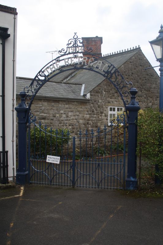
THE DRIVE
1.
1614
Nos 1 and 2
(The Retreat
Almshouses).
TQ 5355/2/170
II
2.
With Nos 3 to 8 (consec). Range of late C19 almshouses, built in
traditional colligrate style. One storey with attic. Stone with
some brick dressings. Slate-roof. Porches with tudor arched
doorways, mullioned windows. Composition is crowned by prominent
twisted chimney stacks in red brick.
Listing NGR: TQ5302755077
External links are from the relevant listing authority and, where applicable, Wikidata. Wikidata IDs may be related buildings as well as this specific building. If you want to add or update a link, you will need to do so by editing the Wikidata entry.


Other nearby listed buildings
