Approximate Location Map
Large Map »
Latitude: 51.2703 / 51°16'13"N
Longitude: 0.1932 / 0°11'35"E
OS Eastings: 553094
OS Northings: 154636
OS Grid: TQ530546
Mapcode National: GBR MN4.7PD
Mapcode Global: VHHPS.9BHJ
Plus Code: 9F3275CV+47
Entry Name: 86, High Street
Listing Date: 29 September 1972
Grade: II
Source: Historic England
Source ID: 1281275
English Heritage Legacy ID: 172192
ID on this website: 101281275
Location: Sevenoaks, Kent, TN13
County: Kent
District: Sevenoaks
Civil Parish: Sevenoaks
Built-Up Area: Sevenoaks
Traditional County: Kent
Lieutenancy Area (Ceremonial County): Kent
Church of England Parish: Sevenoaks St Nicholas
Church of England Diocese: Rochester
Tagged with: Building
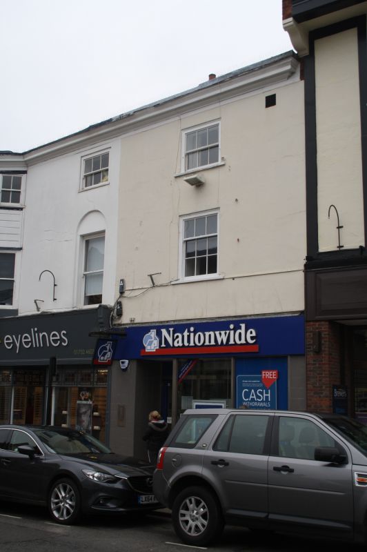
HIGH STREET
1.
1614
(East Side)
No 86
TQ 5354/1/17
II GV
2.
Late C18. One window facade of 3 storeys. stucco. Moulded wooden cornice
and concealed leaded gutter. Modern shop front on ground floor. First and
second floors with one sash window each with Venetian strutters. Ridge tile
roof, hipped to right and forming continuous ridge with No 88.
Nos 86 to 92 (even) form a group.
Listing NGR: TQ5309454636
External links are from the relevant listing authority and, where applicable, Wikidata. Wikidata IDs may be related buildings as well as this specific building. If you want to add or update a link, you will need to do so by editing the Wikidata entry.


Other nearby listed buildings
