Approximate Location Map
Large Map »
Latitude: 51.3887 / 51°23'19"N
Longitude: 0.5058 / 0°30'20"E
OS Eastings: 574444
OS Northings: 168501
OS Grid: TQ744685
Mapcode National: GBR PPN.W4F
Mapcode Global: VHJLT.QC77
Plus Code: 9F329GQ4+F8
Entry Name: La Providence
Listing Date: 19 December 1970
Last Amended: 17 January 1992
Grade: II
Source: Historic England
Source ID: 1336124
English Heritage Legacy ID: 173064
Also known as: French Hospital
1-40, La Providence
ID on this website: 101336124
Location: Rochester, Medway, Kent, ME1
County: Medway
Electoral Ward/Division: Rochester West
Parish: Non Civil Parish
Built-Up Area: Rochester
Traditional County: Kent
Lieutenancy Area (Ceremonial County): Kent
Church of England Parish: Rochester St Peter Parish Centre
Church of England Diocese: Rochester
Tagged with: Almshouse
In the entry for
ROCHESTER HIGH STREET
TQ 7468 AND TQ 7468 NW
7/134; 9/134 Nos 1-20, 21-31, and
33-40, La Providence
19.12.1979 (formerly Theobold
Square)
GV II
The Address and the Description shall be amended to read
TQ 7468 SW AND TQ 7468 NW ROCHESTER HIGH STREET
7/134; 9/134 Nos 1-20, 21-31, and
32-40, La Providence
19.12.1970 (formerly Theobold
Square)
GV II
Last but one sentence shall be amended to read "Nos 32-40 ----"
------------------------------------
ROCHESTER HIGH STREET
TQ 7468 AND TQ 7468 NW
7/134; 9/134 Nos 1-20, 21-31
and 33-40 La
Providence
19.12.70 (formerly Theobald
Square)
GV II
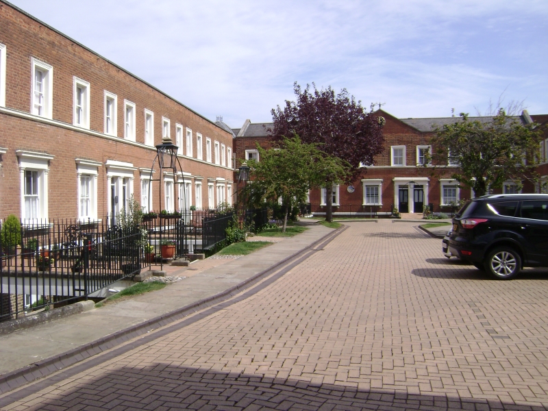
Almshouses; founded 1718 for poor French protestants and their
descendants. The present buildings are mid C19, substantially
renovated in 1957-9 by Grellier and Sons, who retained the front
elevations. Red brick; Welsh slate roofs. The almshouses are
grouped as 3 terraces forming 3 sides of a square. 2 storeys,
with basement and area, the front doors approached by means of
bridges with simple railings. Nos 1-20 (to left, W, of square),
an 18-window range; parapet with stone coping, 1st floor lintel
band and plat band between ground floor and basement 4-pane
horned sash windows in moulded surrounds, and cornices to ground
floor only. Doorways arranged in pairs with pilasters and
cornice; half-glazed doors. Sash windows to basement. Nos 21-31
a 10 window range, similar but with a central pediment,
containing a clock. Nos 33-40, a 10-window range opposite Nos
21-31, and identically treated. Rear elevations with sash
windows.
Listing NGR: TQ7423868684
External links are from the relevant listing authority and, where applicable, Wikidata. Wikidata IDs may be related buildings as well as this specific building. If you want to add or update a link, you will need to do so by editing the Wikidata entry.


Other nearby listed buildings
