Approximate Location Map
Large Map »
Latitude: 51.2734 / 51°16'24"N
Longitude: 0.5234 / 0°31'24"E
OS Eastings: 576113
OS Northings: 155718
OS Grid: TQ761557
Mapcode National: GBR PR7.14Y
Mapcode Global: VHJMF.1825
Plus Code: 9F327GFF+99
Entry Name: 14, Gabriel's Hill
Listing Date: 2 August 1974
Grade: II
Source: Historic England
Source ID: 1086343
English Heritage Legacy ID: 173327
ID on this website: 101086343
Location: Maidstone, Kent, ME15
County: Kent
District: Maidstone
Electoral Ward/Division: High Street
Parish: Non Civil Parish
Built-Up Area: Maidstone
Traditional County: Kent
Lieutenancy Area (Ceremonial County): Kent
Tagged with: Building
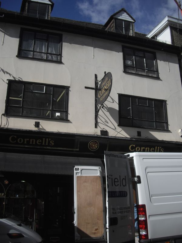
GABRIEL'S HILL
1.
5278
(South-West Side)
No 14
TQ 7655 NW 2/258
II GV
2.
C18 altered. 3 storeys stuccoed. Old tiled roof with 2 hipped dormers. 2
altered modern metal framed casements. C19 shopfront with panelled risers.
Nos 4 to 20 (even) form a group.
Listing NGR: TQ7610955719
External links are from the relevant listing authority and, where applicable, Wikidata. Wikidata IDs may be related buildings as well as this specific building. If you want to add or update a link, you will need to do so by editing the Wikidata entry.


Other nearby listed buildings
