Approximate Location Map
Large Map »
Latitude: 51.2702 / 51°16'12"N
Longitude: 0.5805 / 0°34'49"E
OS Eastings: 580105
OS Northings: 155499
OS Grid: TQ801554
Mapcode National: GBR PR9.9L5
Mapcode Global: VHJMG.0BQM
Plus Code: 9F327HCJ+35
Entry Name: Table Tomb 2 Yards South East of Porch of Church of the Holy Cross
Listing Date: 20 July 1984
Grade: II
Source: Historic England
Source ID: 1336248
English Heritage Legacy ID: 173511
ID on this website: 101336248
Location: Holy Cross Church, Bearsted, Maidstone, Kent, ME14
County: Kent
District: Maidstone
Civil Parish: Bearsted
Built-Up Area: Maidstone
Traditional County: Kent
Lieutenancy Area (Ceremonial County): Kent
Tagged with: Table tomb
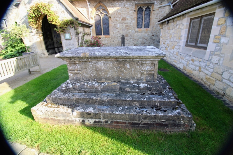
TQ 85 NW BEARSTED CHURCH LANE
(east side)
6/4 Table Tomb
2 yds south east
of porch of Church
of The Holy Cross
II
Table tomb. Early C18. Stone. Moulded plinth and body with
corniced lid. Inscription illegible at time of resurvey.
Listing NGR: TQ8005655732
External links are from the relevant listing authority and, where applicable, Wikidata. Wikidata IDs may be related buildings as well as this specific building. If you want to add or update a link, you will need to do so by editing the Wikidata entry.


Other nearby listed buildings
