Approximate Location Map
Large Map »
Latitude: 51.2957 / 51°17'44"N
Longitude: 0.5712 / 0°34'16"E
OS Eastings: 579357
OS Northings: 158316
OS Grid: TQ793583
Mapcode National: GBR PQX.M78
Mapcode Global: VHJM7.VPBK
Plus Code: 9F327HWC+7F
Entry Name: The Cottage
Listing Date: 20 July 1984
Grade: II
Source: Historic England
Source ID: 1086221
English Heritage Legacy ID: 173638
ID on this website: 101086221
Location: Detling, Maidstone, Kent, ME14
County: Kent
District: Maidstone
Civil Parish: Detling
Built-Up Area: Detling
Traditional County: Kent
Lieutenancy Area (Ceremonial County): Kent
Tagged with: Cottage
TQ 75 NE DETLING PILGRIMS WAY
(south side)
5/131 The Cottage
II
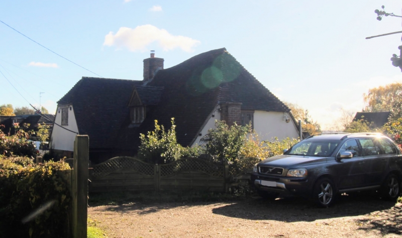
House. C15 or C16. Timber framed with gault brick cladding to
left and rendered infilling to right. Plain tile roof. One
storey and attic. Steeply pitched roof gabled to left, half-
hipped to right. Multiple brick ridge stack at left end and
small projecting brick stack at right end. Dormer off-centre
to left, with 3-light ground floor casement beneath. C20 half-
glazed door in C20 brick extension to front at left end.
Listing NGR: TQ7936058315
External links are from the relevant listing authority and, where applicable, Wikidata. Wikidata IDs may be related buildings as well as this specific building. If you want to add or update a link, you will need to do so by editing the Wikidata entry.


Other nearby listed buildings
