Approximate Location Map
Large Map »
Latitude: 51.2459 / 51°14'45"N
Longitude: 0.682 / 0°40'55"E
OS Eastings: 587288
OS Northings: 153051
OS Grid: TQ872530
Mapcode National: GBR QSY.Z44
Mapcode Global: VHJMH.RYY9
Plus Code: 9F326MWJ+9R
Entry Name: Court Lodge Farm House
Listing Date: 26 April 1968
Last Amended: 14 December 1984
Grade: II
Source: Historic England
Source ID: 1336292
English Heritage Legacy ID: 173752
ID on this website: 101336292
Location: Harrietsham, Maidstone, Kent, ME17
County: Kent
District: Maidstone
Town: Maidstone
Civil Parish: Harrietsham
Built-Up Area: Harrietsham
Traditional County: Kent
Lieutenancy Area (Ceremonial County): Kent
Tagged with: Farmhouse
HARRIETSHAM CHURCH ROAD
TQ 85 SE (north side)
4/19 Court Lodge Farm House
(formerly listed as The
26.4.68. Court Lodge)
GV II
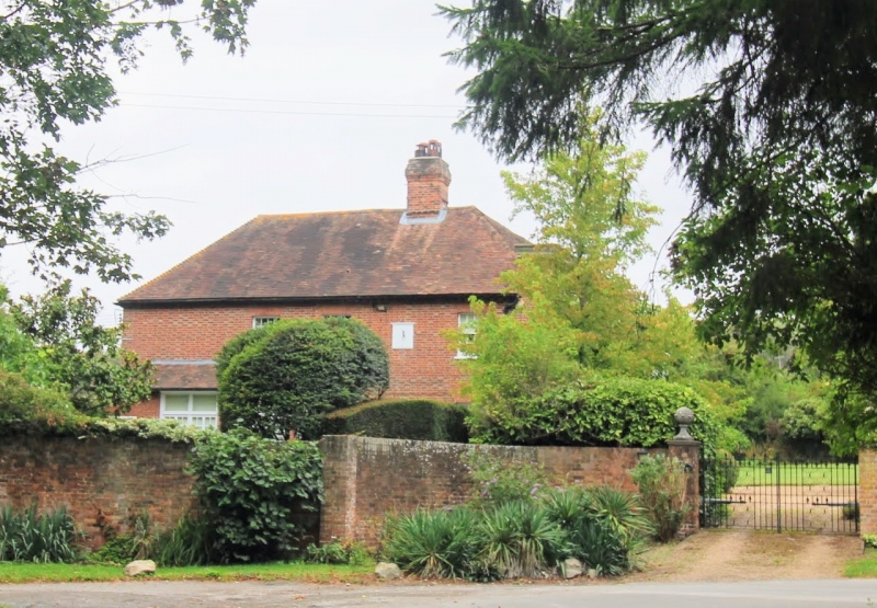
House, now farmhouse. Early C19, before 1823, possibly with C18 core.
Red brick in Flemish bond. Left side elevation chequered red
and grey brick. Plain tile roof. Double depth, with facade to
gable end. 2 storeys on brick plinth with moulded wood eaves cornice.
Parapet with early C20 dentilled cement cornice. Dentilled brick
cornice to rest of building. Hipped roof across both ranges, with
hip returning along side elevations. 2 rear hips. Brick ridge stack
to each rear range. Regular fenestration of 2 casements with marginal
lights and central semi-circular headed window. Fluted segmental
band over each ground-floor window. Central recessed panelled door
with semi-circular fanlight with radiating glazing bars. Door-
case with pilasters and broken triangular pediment. Early C20
porch with 2 Doric columns and flat corniced hood. Extension of circa
1903 to right in similar style. Drawing of 1823. Interior not
inspected,
Listing NGR: TQ8728653052
External links are from the relevant listing authority and, where applicable, Wikidata. Wikidata IDs may be related buildings as well as this specific building. If you want to add or update a link, you will need to do so by editing the Wikidata entry.


Other nearby listed buildings
