Approximate Location Map
Large Map »
Latitude: 51.2131 / 51°12'47"N
Longitude: 0.5898 / 0°35'23"E
OS Eastings: 580977
OS Northings: 149173
OS Grid: TQ809491
Mapcode National: GBR PRW.ZWP
Mapcode Global: VHJMN.5RNX
Plus Code: 9F326H7Q+6W
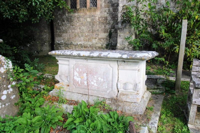
Entry Name: Table Tomb About 10 Metres South West of Church of St Mary
Listing Date: 18 December 1985
Grade: II
Source: Historic England
Source ID: 1060906
English Heritage Legacy ID: 174144
ID on this website: 101060906
Location: St Mary's Church, Sutton Valence, Maidstone, Kent, ME17
County: Kent
District: Maidstone
Civil Parish: Sutton Valence
Built-Up Area: Sutton Valence
Traditional County: Kent
Lieutenancy Area (Ceremonial County): Kent
Tagged with: Building
SUTTON VALENCE CHART STREET
TQ 8049-8149
(north side)
7/125 Table tomb about
10 metres south-
west of Church
of St Mary
GV II
Table tomb. Early C18. Stone, on stepped stone base, with
moulded plinth, corniced lid and moulded side panels.
Inscription to east end illegible at time of re-survey. Date
of death 173(?)
Listing NGR: TQ8097749173
External links are from the relevant listing authority and, where applicable, Wikidata. Wikidata IDs may be related buildings as well as this specific building. If you want to add or update a link, you will need to do so by editing the Wikidata entry.


Other nearby listed buildings
