Approximate Location Map
Large Map »
Latitude: 51.2213 / 51°13'16"N
Longitude: 0.5348 / 0°32'5"E
OS Eastings: 577106
OS Northings: 149948
OS Grid: TQ771499
Mapcode National: GBR PRT.B0Z
Mapcode Global: VHJMM.7K2N
Plus Code: 9F326GCM+GW
Entry Name: Barn About 15 Metres South West of Boughton Monchelsea Place
Listing Date: 27 July 1952
Grade: II
Source: Historic England
Source ID: 1060752
English Heritage Legacy ID: 174470
ID on this website: 101060752
Location: Maidstone, Kent, ME17
County: Kent
District: Maidstone
Civil Parish: Boughton Monchelsea
Traditional County: Kent
Lieutenancy Area (Ceremonial County): Kent
Tagged with: Barn
BOUGHTON MONCHELSEA CHURCH HILL
TQ 74 NE (East side)
2/10 Barn about 15
metres south-
west of Boughton
27.7.52 Monchelsea
Place
GV II
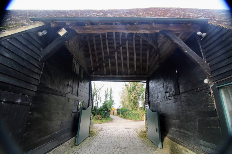
Barn. C15 or early C16, with late C18 or early C19 alterations. Timber framed. North section of west aisle wall weatherboarded, south section red brick in Flemish bond. South gable end weatherboarded on stone plinth. South wall of return wing partly weatherboarded, partly with exposed broadly-spaced
studding with red and grey brick infilling on stone plinth. Plain tile roof. Approximately 8 timber-framed bays, with side aisles, end aisle to south, and possibly also to north. A further 2 or 3 bays to north, probably added or
rebuilt in late C18 or early C19. Section of single-storey height, possibly a
C16 addition, running east from south end of east elevation of main barn. Steeply-pitched roof to main barn, hipped with gablet to south, half-hipped
to north. 6 hipped dormers to west slope of roof; 2 deep eaves dormers and
one smaller roof dormer with small paned lights to south side of carriage entrance, and 3 small roof dormers to north, one with a multi-paned 2-light casement, one boarded and one louvred. Carriage entrance with weatherboarded sides formed in the fifth timber-framed bay from the south, roofed as far as
the arcade plate, and with aisles discontinued. Further midstreys to second
and seventh bays from south, the latter with bracketed canopy, the former
with low lean-to roof. Single-storey section has pair of conjoined rendered gables towards east end of north elevation. Lower 2-storey addition to north
end; timber framed, with broadly-spaced studding, brick infilling, and half-hipped plain tile roof.
Interior: only partly inspected. Largely floored. Gunstock-jowled posts,
arch-braced to tie beams and arcade-plates. Crown-post roof, but with few
crown-posts surviving. Original studs and bracing to parts of aisles. Edge-
halved scarf joint to arcade plate. Late C18 or early C19 roof of staggered
butt purlins with king posts to north end. Barn, with single-storey wing,
shown on print of c.1720 (Country Life June 20th 1963).
Listing NGR: TQ7710649948
External links are from the relevant listing authority and, where applicable, Wikidata. Wikidata IDs may be related buildings as well as this specific building. If you want to add or update a link, you will need to do so by editing the Wikidata entry.


Other nearby listed buildings
