Approximate Location Map
Large Map »
Latitude: 51.173 / 51°10'22"N
Longitude: 0.4977 / 0°29'51"E
OS Eastings: 574698
OS Northings: 144492
OS Grid: TQ746444
Mapcode National: GBR PSC.DMR
Mapcode Global: VHJMS.KSZ5
Plus Code: 9F325FFX+53
Entry Name: Marden Farm Shop
Listing Date: 23 May 1967
Last Amended: 23 March 1987
Grade: II
Source: Historic England
Source ID: 1038292
English Heritage Legacy ID: 174736
ID on this website: 101038292
Location: Marden, Maidstone, Kent, TN12
County: Kent
District: Maidstone
Civil Parish: Marden
Built-Up Area: Marden
Traditional County: Kent
Lieutenancy Area (Ceremonial County): Kent
Tagged with: Building
SEVENTY FOURTH LIST OF BUILDINGS OF SPECIAL ARCHITECTURAL OR HISTORIC INTEREST
COMPILED UNDER SECTION 54 OF THE TOWN AND COUNTRY PLANNING ACT 1971
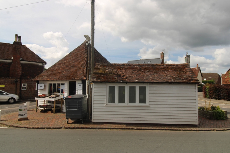
TQ 7444 MARDEN HIGH STREET
(south-east end)
5/78 Marden Farm Shop (formerly
listed as The Old Market
23.5.67 House)
GV II
Court house, probably also with market function, now shop. Probably
C16, with late C17 or early C18 and C19 alterations. Timber framed,
weatherboarded, with exposed corner posts. Plain tile roof.
Virtually square building of 2 timber-framed bays, built at
right-angles to Howland Road on an island site at the end of the
High Street. Single storey, on stone plinth. Pyramidal roof. Eight-
pane shop window with thin glazing bars to present front elevation
(to Howland Road), and two six-pane windows to right side. Half-
glazed door to right side of front elevation. Interior: exposed
framing. Short shaped jowls to principal posts. Dragon ties to
corners. Clasped-purlin roof. Each rafter has mortice at same height
towards apex. Curved arch-braces to left side wall and part of gable
ends. Right side wall-plate and short return along each gable end
morticed for continuous row of diamond mullions; some mullions
remain in situ, apparently terminating at midrail. Road island site.
Court Leet said to have been held here until C19.
Listing NGR: TQ7469844492
External links are from the relevant listing authority and, where applicable, Wikidata. Wikidata IDs may be related buildings as well as this specific building. If you want to add or update a link, you will need to do so by editing the Wikidata entry.


Other nearby listed buildings
