Approximate Location Map
Large Map »
Latitude: 51.072 / 51°4'19"N
Longitude: 1.0833 / 1°5'0"E
OS Eastings: 616101
OS Northings: 134825
OS Grid: TR161348
Mapcode National: GBR V0L.QPL
Mapcode Global: FRA F649.5VM
Plus Code: 9F3333CM+R8
Entry Name: 5-9, Church Hill
Listing Date: 21 December 1973
Grade: II
Source: Historic England
Source ID: 1344072
English Heritage Legacy ID: 175087
ID on this website: 101344072
Location: Hythe, Folkestone and Hythe, Kent, CT21
County: Kent
District: Folkestone and Hythe
Civil Parish: Hythe
Built-Up Area: Hythe
Traditional County: Kent
Lieutenancy Area (Ceremonial County): Kent
Tagged with: Building
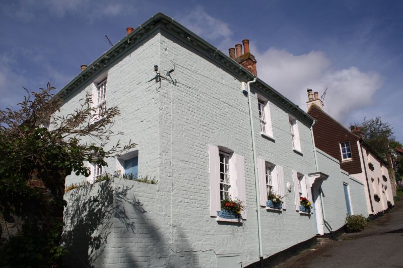
1.
1253 CHURCH HILL
(South West Side)
Nos 5 to 9 (odd)
TR 1634 NW 2/86
II GV
2.
Mid C19. 2 storeys painted brick. Tiled roof with modillion cornice. 2 to
3 cambered sashes. Right side doorcase with flat hood on brackets. Simple
panelled door, Included for group value.
Nos 5 to 9 (odd) and Nos 13 to 17 (odd) form a group with Nos 1 and 2 (Centuries)
Bartholomew Street.
Listing NGR: TR1610034821
External links are from the relevant listing authority and, where applicable, Wikidata. Wikidata IDs may be related buildings as well as this specific building. If you want to add or update a link, you will need to do so by editing the Wikidata entry.


Other nearby listed buildings
