Approximate Location Map
Large Map »
Latitude: 51.0717 / 51°4'18"N
Longitude: 1.0856 / 1°5'8"E
OS Eastings: 616264
OS Northings: 134792
OS Grid: TR162347
Mapcode National: GBR V0L.R9N
Mapcode Global: FRA F659.0SL
Plus Code: 9F3333CP+M7
Entry Name: 93 and 93A, High Street
Listing Date: 21 December 1973
Grade: II
Source: Historic England
Source ID: 1344076
English Heritage Legacy ID: 175112
ID on this website: 101344076
Location: Hythe, Folkestone and Hythe, Kent, CT21
County: Kent
District: Folkestone and Hythe
Civil Parish: Hythe
Built-Up Area: Hythe
Traditional County: Kent
Lieutenancy Area (Ceremonial County): Kent
Tagged with: Building
1.
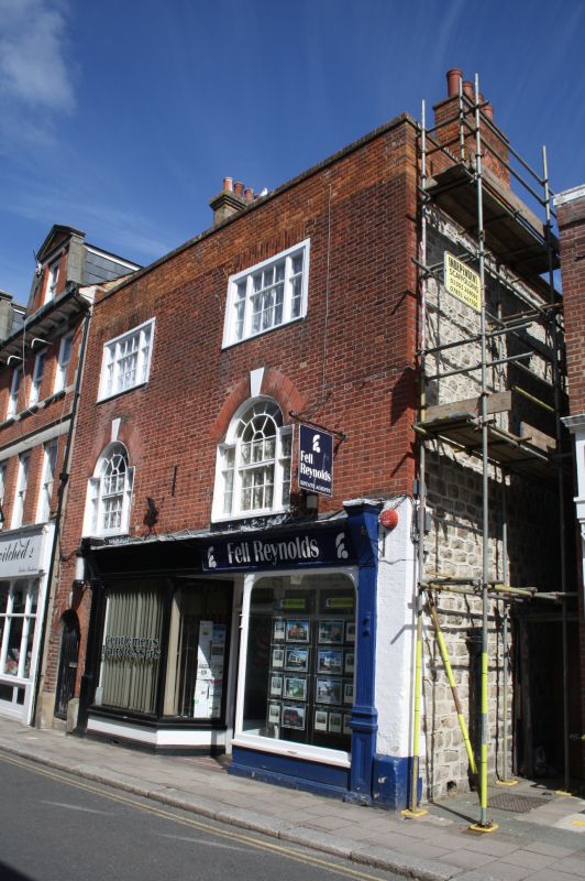
1253 HIGH STREET
(North Side)
Nos 93 and 93A
TR 1634 NW 2/10
II
2.
Originally one house, now sub-divided, C18. 3 storeys red brick, Renewed
parapet. 2 sashes with glazing bars intact on the upper floors and Venetian
windows on the 1st floor. Modern shop fronts. Left side round-arched doorcase
to No 93A.
Listing NGR: TR1626434797
External links are from the relevant listing authority and, where applicable, Wikidata. Wikidata IDs may be related buildings as well as this specific building. If you want to add or update a link, you will need to do so by editing the Wikidata entry.


Other nearby listed buildings
