Approximate Location Map
Large Map »
Latitude: 51.0715 / 51°4'17"N
Longitude: 1.0856 / 1°5'8"E
OS Eastings: 616262
OS Northings: 134774
OS Grid: TR162347
Mapcode National: GBR V0L.R8M
Mapcode Global: FRA F659.0RL
Plus Code: 9F3333CP+J6
Entry Name: 112 and 112A, High Street
Listing Date: 21 December 1973
Grade: II
Source: Historic England
Source ID: 1186018
English Heritage Legacy ID: 175123
ID on this website: 101186018
Location: Hythe, Folkestone and Hythe, Kent, CT21
County: Kent
District: Folkestone and Hythe
Civil Parish: Hythe
Built-Up Area: Hythe
Traditional County: Kent
Lieutenancy Area (Ceremonial County): Kent
Tagged with: Building
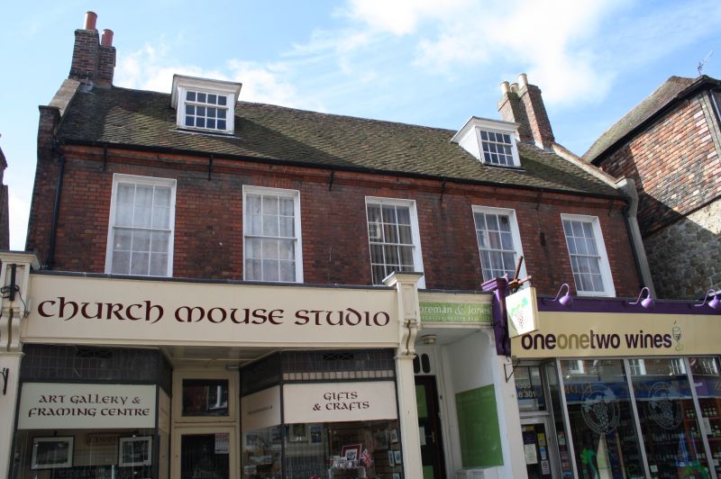
1. HIGH STREET
1253 (South Side)
Nos 112 and 112A
TR 1634 NW 2/22
II GV
2.
One house, 2 shops. C18. 2 storeys and attics red brick. Roof has 2 dormers
and moulded brick eaves cornice. 5 sashes with glazing bars intact on 1st floor.
Modern shop fronts built out on front of the house. Doorcase up 5 steps in
the centre with rectangular fanlight and 6-panel moulded door.
Nos 94 to 98 (even), No 102 and Nos 106 to 130 (even) form a group.
Listing NGR: TR1625934770
External links are from the relevant listing authority and, where applicable, Wikidata. Wikidata IDs may be related buildings as well as this specific building. If you want to add or update a link, you will need to do so by editing the Wikidata entry.


Other nearby listed buildings
