Approximate Location Map
Large Map »
Latitude: 51.0729 / 51°4'22"N
Longitude: 1.0938 / 1°5'37"E
OS Eastings: 616830
OS Northings: 134950
OS Grid: TR168349
Mapcode National: GBR V0M.MCF
Mapcode Global: FRA F658.XM7
Plus Code: 9F3333FV+5G
Entry Name: 7-13, Mill Road
Listing Date: 21 December 1973
Grade: II
Source: Historic England
Source ID: 1186202
English Heritage Legacy ID: 175154
ID on this website: 101186202
Location: Hythe, Folkestone and Hythe, Kent, CT21
County: Kent
District: Folkestone and Hythe
Civil Parish: Hythe
Built-Up Area: Hythe
Traditional County: Kent
Lieutenancy Area (Ceremonial County): Kent
Tagged with: Building
1.
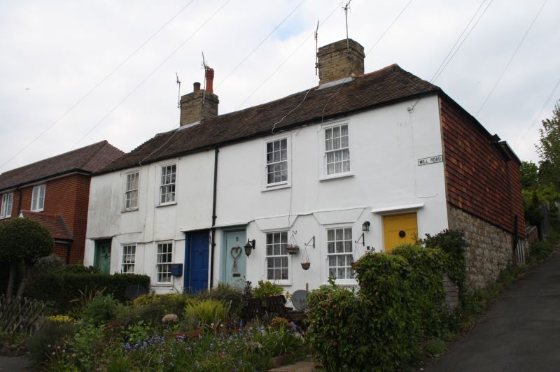
1253 MILL ROAD
Nos 7 to 13 (odd)
TR 1634 NE 3/130
II GV
2.
An early C19 range. 2 storeys stuccoed. Hipped tiled roof. 4 sashes with
glazing bars intact. Doors have simple weather hoods and 6 flush panelled doors.
Nos 3 to 13 (odd) form a group.
Listing NGR: TR1683034950
External links are from the relevant listing authority and, where applicable, Wikidata. Wikidata IDs may be related buildings as well as this specific building. If you want to add or update a link, you will need to do so by editing the Wikidata entry.


Other nearby listed buildings
