Approximate Location Map
Large Map »
Latitude: 51.0668 / 51°4'0"N
Longitude: 1.0841 / 1°5'2"E
OS Eastings: 616180
OS Northings: 134244
OS Grid: TR161342
Mapcode National: GBR V0S.4WP
Mapcode Global: FRA F659.D5X
Plus Code: 9F33338M+PJ
Entry Name: 110 and 112, Stade Street
Listing Date: 21 December 1973
Grade: II
Source: Historic England
Source ID: 1344129
English Heritage Legacy ID: 175177
ID on this website: 101344129
Location: Hythe, Folkestone and Hythe, Kent, CT21
County: Kent
District: Folkestone and Hythe
Civil Parish: Hythe
Built-Up Area: Hythe
Traditional County: Kent
Lieutenancy Area (Ceremonial County): Kent
Tagged with: Building
1.
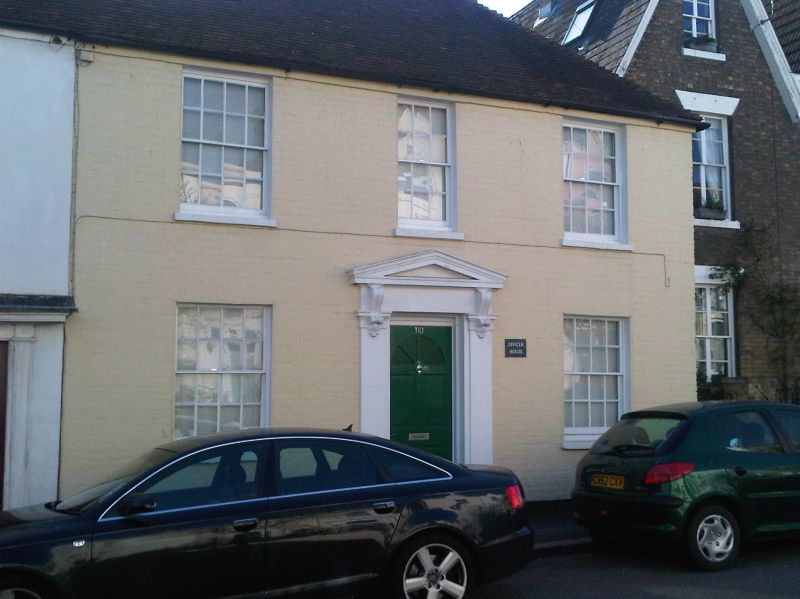
1253 STADE STREET
(South West Side)
Nos 110 and 112
TR 13 SE 5/69
II
2.
Early C19. 2 storeys. No 110 is of painted brick and No 112 is cemented. Hipped
tiled roof. 4 sashes with glazing bars intact. No 110 has a later doorcase
with pilasters, pediment supported on console brackets and a rectangular fanlight.
No 112 has a doorcase with fluted pilasters and projecting cornice.
Listing NGR: TR1618034244
External links are from the relevant listing authority and, where applicable, Wikidata. Wikidata IDs may be related buildings as well as this specific building. If you want to add or update a link, you will need to do so by editing the Wikidata entry.


Other nearby listed buildings
