Approximate Location Map
Large Map »
Latitude: 51.0715 / 51°4'17"N
Longitude: 1.0777 / 1°4'39"E
OS Eastings: 615712
OS Northings: 134750
OS Grid: TR157347
Mapcode National: GBR V0L.P9Q
Mapcode Global: FRA F649.3PD
Plus Code: 9F3333CH+J3
Entry Name: Military Terrace
Listing Date: 23 October 1974
Grade: II
Source: Historic England
Source ID: 1068930
English Heritage Legacy ID: 175184
ID on this website: 101068930
Location: Hythe, Folkestone and Hythe, Kent, CT21
County: Kent
District: Folkestone and Hythe
Civil Parish: Hythe
Built-Up Area: Hythe
Traditional County: Kent
Lieutenancy Area (Ceremonial County): Kent
Tagged with: Building
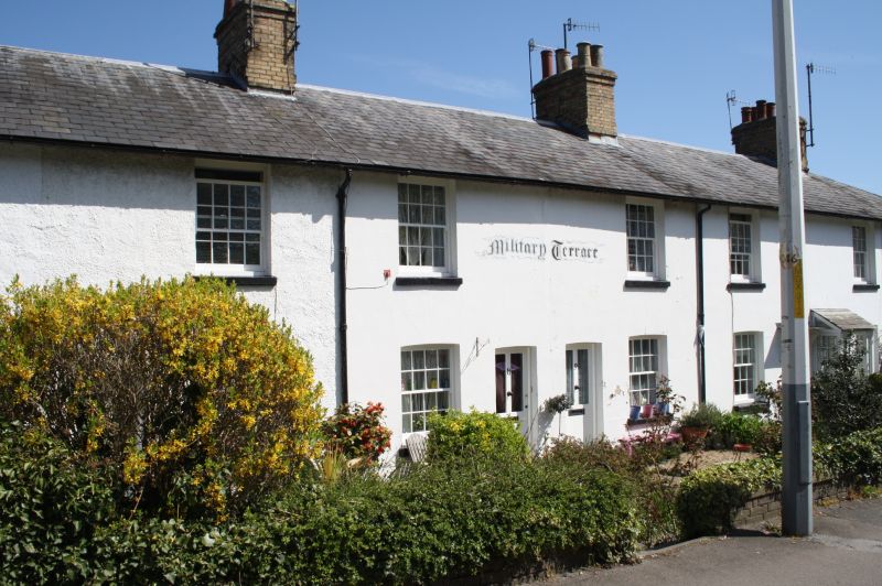
1.
1253 MILITARY ROAD
(North Side)
Military Side
[Nos 3 to 17 (odd)]
TR 1534 NE 1/120
II GV
2.
A Mid C19 terrace. 2 storeys stuccoed. Nos 13 and 15 are roughcast. Hipped slate roof.
1 sash to each with glazing bars intact. Simple doorcases. Later porch to No 5.
Nos 3 to 17 (odd) Military Terrace form a group.
Listing NGR: TR1571234750
External links are from the relevant listing authority and, where applicable, Wikidata. Wikidata IDs may be related buildings as well as this specific building. If you want to add or update a link, you will need to do so by editing the Wikidata entry.


Other nearby listed buildings
