Approximate Location Map
Large Map »
Latitude: 50.9515 / 50°57'5"N
Longitude: 0.9059 / 0°54'21"E
OS Eastings: 604205
OS Northings: 120920
OS Grid: TR042209
Mapcode National: GBR T0L.7VR
Mapcode Global: FRA D6SL.GRQ
Plus Code: 9F22XW24+J9
Entry Name: High Street House
Listing Date: 30 January 1973
Grade: II
Source: Historic England
Source ID: 1338203
English Heritage Legacy ID: 175210
ID on this website: 101338203
Location: Lydd, Folkestone and Hythe, Kent, TN29
County: Kent
District: Folkestone and Hythe
Civil Parish: Lydd
Built-Up Area: Lydd
Traditional County: Kent
Lieutenancy Area (Ceremonial County): Kent
Tagged with: House
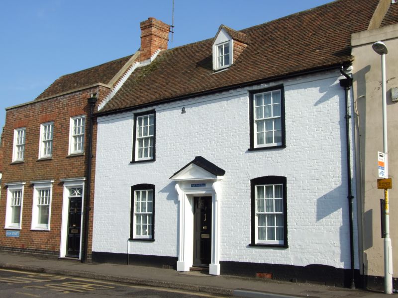
HIGH STREET
1.
1355
(South-East Side)
No 7
(High Street House)
TR 0420 NW 1/3
II GV
2.
Early C19. 2 storeys and attics painted brick. Tiled roof with modillion
cornice and 1 gabled dormer. 2 sashes with glazing bars intact. Doorcase
set in a moulded surround with pediment over supported on consoles and
6-panel door, the top 2 panels cut away and glazed.
Nos 7 to 17 (odd) form a group.
Listing NGR: TR0420720918
External links are from the relevant listing authority and, where applicable, Wikidata. Wikidata IDs may be related buildings as well as this specific building. If you want to add or update a link, you will need to do so by editing the Wikidata entry.


Other nearby listed buildings
