Approximate Location Map
Large Map »
Latitude: 51.0245 / 51°1'28"N
Longitude: 0.9922 / 0°59'31"E
OS Eastings: 609932
OS Northings: 129277
OS Grid: TR099292
Mapcode National: GBR SZQ.RND
Mapcode Global: FRA D6ZD.SDY
Plus Code: 9F322XFR+RV
Entry Name: Dunkirk End and Herring Hang Attached
Listing Date: 23 April 1985
Grade: II
Source: Historic England
Source ID: 1344176
English Heritage Legacy ID: 175527
ID on this website: 101344176
Location: Dymchurch, Folkestone and Hythe, Kent, TN29
County: Kent
District: Folkestone and Hythe
Civil Parish: Dymchurch
Built-Up Area: Dymchurch
Traditional County: Kent
Lieutenancy Area (Ceremonial County): Kent
Tagged with: Architectural structure
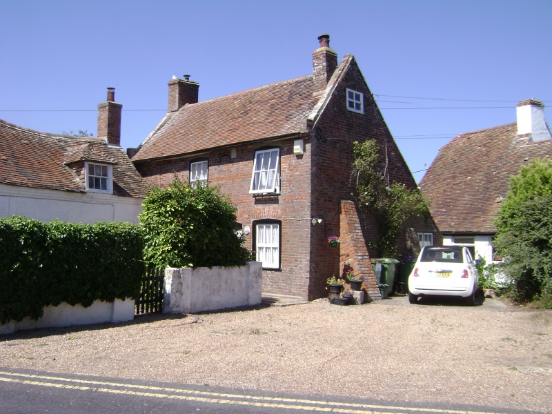
TR 099 293 DYMCHURCH MILL ROAD
(north side)
7/69 Dunkirk End and Herring
Hang attached
GV II
House. Early-to-mid C18 with C19 alterations. Red brick with occasional
grey headers in Flemish bond. Plain tile roof. Set back from road. 2
storeys and garret on brick plinth. Slightly projecting eaves with flat
soffits. Brick-coped gable ends with brick kneelers. Gable end stack to
right in front slope of roof and gable end stack to left. Irregular
fenestration of two 6-pane glazing bar sashes only slightly recessed. 3
ground floor glazing bar sashes with segmental heads. Boarded door with
segmental head off-centre to left, between 2 first floor windows. Integral
rear lean-to. Datestone between first floor windows: A.K.
R.H.
1736
Interior not inspected. Herring hang or kipper house. Probably C19.
Attached to left gable end of house. Brick on submerged stone plinth with
plain tile roof. Rectangular, much narrower than house and about two-thirds
the height. Very small wooden hatch or smoke outlet in left gable end.
towards apex, and 2 small rectangular vents towards base. Boarded door to
rear against junction with house. Interior: down deep step. 7 smoke-blackened
wooden bars remain intact, axially placed at intervals of about 1 foot, from 7
feet from ground to just below gable hitch. Corresponding brick ledges to long
walls to take other ends of rods or speets (now gone) placed across the building
and threaded with fish. Walls of hang smoke-blackened except at base.
Listing NGR: TR1000229234
External links are from the relevant listing authority and, where applicable, Wikidata. Wikidata IDs may be related buildings as well as this specific building. If you want to add or update a link, you will need to do so by editing the Wikidata entry.


Other nearby listed buildings
