Approximate Location Map
Large Map »
Latitude: 51.3517 / 51°21'6"N
Longitude: 0.6688 / 0°40'7"E
OS Eastings: 585938
OS Northings: 164780
OS Grid: TQ859647
Mapcode National: GBR QRS.7XJ
Mapcode Global: VHJM3.J9Y4
Plus Code: 9F329M29+MG
Entry Name: The Holme
Listing Date: 24 January 1967
Grade: II
Source: Historic England
Source ID: 1069348
English Heritage Legacy ID: 176168
ID on this website: 101069348
Location: Newington, Swale, Kent, ME9
County: Kent
District: Swale
Civil Parish: Newington
Built-Up Area: Newington
Traditional County: Kent
Lieutenancy Area (Ceremonial County): Kent
Tagged with: Building
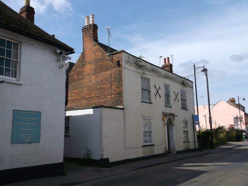
TQ 86 SE NEWINGTON HIGH STREET
(south side)
5/7 No. 56 (The Holme)
24.1.67
GV II
House. Early C19. Painted brick and slate roof. Two storeys on
plinth with parapet and stacks to left and right. Regular fenestra-
tion of 3 later C19 glazing bar sashes on first floor and 2 on
ground floor, all with gauged heads. Central door of 6 panels with
semi-circular fanlight, moulded surrounds and cornice hood on
consoles.
Listing NGR: TQ8593864780
External links are from the relevant listing authority and, where applicable, Wikidata. Wikidata IDs may be related buildings as well as this specific building. If you want to add or update a link, you will need to do so by editing the Wikidata entry.


Other nearby listed buildings
