Approximate Location Map
Large Map »
Latitude: 51.2219 / 51°13'18"N
Longitude: 1.4042 / 1°24'15"E
OS Eastings: 637801
OS Northings: 152476
OS Grid: TR378524
Mapcode National: GBR X1Y.7TZ
Mapcode Global: VHMDG.9K64
Plus Code: 9F336CC3+QM
Entry Name: Timeball Tower Museum
Listing Date: 8 February 1974
Grade: II
Source: Historic England
Source ID: 1069907
English Heritage Legacy ID: 176935
ID on this website: 101069907
Location: Deal, Dover, Kent, CT14
County: Kent
District: Dover
Civil Parish: Deal
Built-Up Area: Deal
Traditional County: Kent
Lieutenancy Area (Ceremonial County): Kent
Tagged with: Building
This list entry was subject to a Minor Amendment on 07/10/2019
TR 3752 SE
4/180
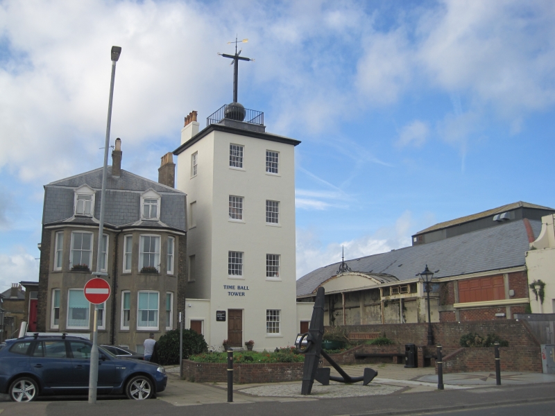
Victoria Parade
Timeball Tower Museum
(Formerly listed as Timeball Tower, BEACH STREET (West Side))
II
Originally this building, situated at the entrance to the old Navy Yard, was one of 10 royal signal towers used to semaphore messages to the Admiralty from tile fleet at the Downs during the Napoleonic Wars. However, the semaphore line was never completed. Instead the semaphore tower became the headquarters for the coast blockade for the suppression of smuggling until 1831.
In 1855 the tower was adapted to form a Time-Ball Tower. At Greenwich in 1855 the 1st Time Ball was installed to enable ships on the Thames to check their chronometers. In 1855 a similar Time Ball of copper, mounted on a 14 ft mast was installed on top of the old semaphore station in Deal. At 12.55 pm every day the ball was raised halfway, at 12.57 pm it was raised to the top of the mast. At 1 pm at time-signal, direct from Greenwich, was used to operate a slave Shepherd clock at Deal. This relayed the signal to operate the mechanism and allow the ball to drop. This system was in operation until 1927 when it was replaced by wireless time signals.
Built 1820-21, four storeys stuccoed. Hipped slate roof. On top is a copper ball surmounted by a cross with the points of the compass on it and an arrow. Two sashes with glazing bars intact but modern metal casements and doorcase to ground floor.
Listing NGR: TR3780152476
External links are from the relevant listing authority and, where applicable, Wikidata. Wikidata IDs may be related buildings as well as this specific building. If you want to add or update a link, you will need to do so by editing the Wikidata entry.


Other nearby listed buildings
