Approximate Location Map
Large Map »
Latitude: 51.2235 / 51°13'24"N
Longitude: 1.4043 / 1°24'15"E
OS Eastings: 637799
OS Northings: 152647
OS Grid: TR377526
Mapcode National: GBR X1Y.7VJ
Mapcode Global: VHMDG.9H7Y
Plus Code: 9F336CF3+9P
Entry Name: 31, Beach Street
Listing Date: 8 February 1974
Grade: II
Source: Historic England
Source ID: 1363407
English Heritage Legacy ID: 176946
ID on this website: 101363407
Location: Deal, Dover, Kent, CT14
County: Kent
District: Dover
Civil Parish: Deal
Built-Up Area: Deal
Traditional County: Kent
Lieutenancy Area (Ceremonial County): Kent
Tagged with: Building
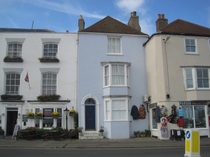
BEACH STREET
1.
lO35
(West Side)
No 31
TR 3752 NE 1/186
II GV
2.
Early C19. 3 storeys and basement stuccoed. Hipped tiled roof. 1 sash window
and 2 1-light bays through ground and 1st floors. Simple round-headed doorcase
with semi-circular fanlight and 4 panelled door. 3 stone steps.
Nos 25 to 31 (odd) and Nos 35 and 37 form a group.
Listing NGR: TR3779952647
External links are from the relevant listing authority and, where applicable, Wikidata. Wikidata IDs may be related buildings as well as this specific building. If you want to add or update a link, you will need to do so by editing the Wikidata entry.


Other nearby listed buildings
