Approximate Location Map
Large Map »
Latitude: 51.2262 / 51°13'34"N
Longitude: 1.4037 / 1°24'13"E
OS Eastings: 637747
OS Northings: 152952
OS Grid: TR377529
Mapcode National: GBR X1Y.1Q8
Mapcode Global: VHMDG.8FYV
Plus Code: 9F336CG3+FF
Entry Name: 2, Brewer Street
Listing Date: 8 February 1974
Grade: II
Source: Historic England
Source ID: 1262879
English Heritage Legacy ID: 177010
ID on this website: 101262879
Location: Deal, Dover, Kent, CT14
County: Kent
District: Dover
Civil Parish: Deal
Built-Up Area: Deal
Traditional County: Kent
Lieutenancy Area (Ceremonial County): Kent
Tagged with: Building
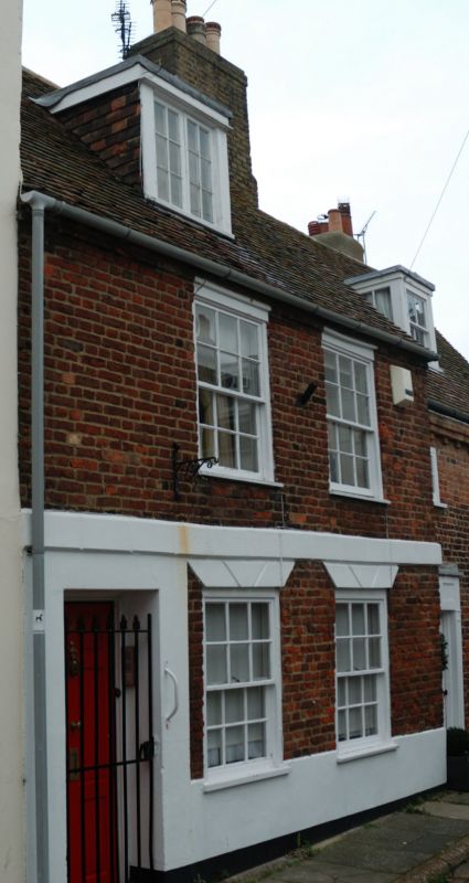
1. BREWER STREET
1035
(North West Side)
No 2
TR 3752 NE 1/65
II GV
2.
Mid to late C18. 2 storeys basement and attics red brick. Old tiled roof with
1 dormer. 2 sashes with glazing bars intact. Rusticated stringcourse and heads
to ground floor windows. Plinth. Simple doorcase.
Nos 1 to 6 (consec) form group.
Listing NGR: TR3774752952
External links are from the relevant listing authority and, where applicable, Wikidata. Wikidata IDs may be related buildings as well as this specific building. If you want to add or update a link, you will need to do so by editing the Wikidata entry.


Other nearby listed buildings
