Approximate Location Map
Large Map »
Latitude: 51.2262 / 51°13'34"N
Longitude: 1.4038 / 1°24'13"E
OS Eastings: 637751
OS Northings: 152955
OS Grid: TR377529
Mapcode National: GBR X1Y.1Q7
Mapcode Global: VHMDG.8FZT
Plus Code: 9F336CG3+FG
Entry Name: 3, Brewer Street
Listing Date: 8 February 1974
Grade: II
Source: Historic England
Source ID: 1363440
English Heritage Legacy ID: 177011
ID on this website: 101363440
Location: Deal, Dover, Kent, CT14
County: Kent
District: Dover
Civil Parish: Deal
Built-Up Area: Deal
Traditional County: Kent
Lieutenancy Area (Ceremonial County): Kent
Tagged with: Building
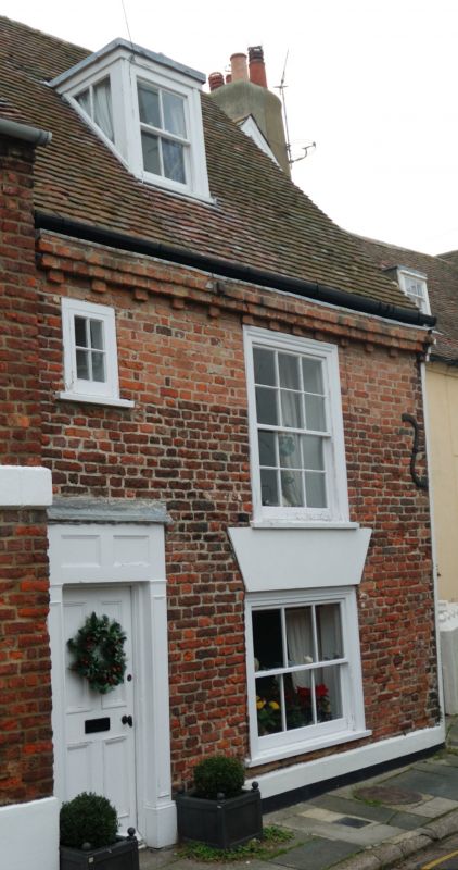
BREWER STREET
1.
1035
(North West Side)
No 3
TR 3752 NE 1/66
II GV
2.
Mid to late C18. 2 storeys and attics red brick. Tiled roof with 1 dormer.
1 sash with verticals only. Left side doorcase with entablature, pilasters and
4 panelled door.
Nos 1 to 6 (consec) form group.
Listing NGR: TR3775152955
External links are from the relevant listing authority and, where applicable, Wikidata. Wikidata IDs may be related buildings as well as this specific building. If you want to add or update a link, you will need to do so by editing the Wikidata entry.


Other nearby listed buildings
