Approximate Location Map
Large Map »
Latitude: 51.2265 / 51°13'35"N
Longitude: 1.4037 / 1°24'13"E
OS Eastings: 637746
OS Northings: 152985
OS Grid: TR377529
Mapcode National: GBR X1Y.1Q4
Mapcode Global: VHMDG.8FYM
Plus Code: 9F336CG3+JF
Entry Name: 16, Coppin Street
Listing Date: 8 February 1974
Grade: II
Source: Historic England
Source ID: 1262723
English Heritage Legacy ID: 177042
ID on this website: 101262723
Location: Deal, Dover, Kent, CT14
County: Kent
District: Dover
Civil Parish: Deal
Built-Up Area: Deal
Traditional County: Kent
Lieutenancy Area (Ceremonial County): Kent
Tagged with: Building
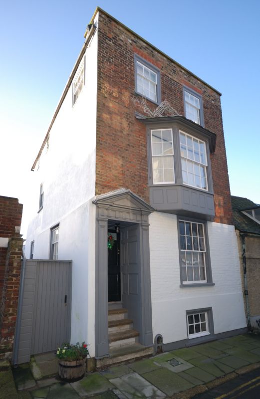
1. COPPIN STREET
1035
(South Side)
No 16
TR 3752 NE 1/71A
II GV
2.
Early C19. 3 storeys and basement red brick, ground floor painted. Parapet
with stone coping. 2:1:1 sashes with glazing bars intact. 3 light bay on 1st
floor. Left side doorcase with pediment, pilasters and triglyph frieze. Panelled
reveals and h panelled door, the top 2 panels cut away and. glazed. 4 steps to
street.
Nos 16 and 17 form a group.
Listing NGR: TR3774652985
External links are from the relevant listing authority and, where applicable, Wikidata. Wikidata IDs may be related buildings as well as this specific building. If you want to add or update a link, you will need to do so by editing the Wikidata entry.


Other nearby listed buildings
