Approximate Location Map
Large Map »
Latitude: 51.2282 / 51°13'41"N
Longitude: 1.4039 / 1°24'14"E
OS Eastings: 637749
OS Northings: 153172
OS Grid: TR377531
Mapcode National: GBR X1R.V25
Mapcode Global: VHMDG.9D1B
Plus Code: 9F336CH3+7H
Entry Name: 13, Griffin Street
Listing Date: 1 June 1949
Grade: II
Source: Historic England
Source ID: 1069849
English Heritage Legacy ID: 177097
ID on this website: 101069849
Location: Deal, Dover, Kent, CT14
County: Kent
District: Dover
Civil Parish: Deal
Built-Up Area: Deal
Traditional County: Kent
Lieutenancy Area (Ceremonial County): Kent
Tagged with: Building
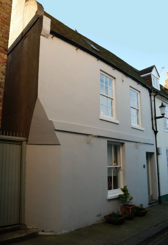
GRIFFIN STREET
1.
1035
(South Side)
No 13
TR 3753 SE 2/95 1.6.49.
II GV
2.
Early C18. 2 storeys and basement cement rendered. Dutch shaped gable. Old
tiled roof with skylight. 2 sashes with glazing bars intact on 1st floor, vertical
only on ground floor. Stringcourse. Right side doorcase with 6 fielded panelled
door, the top 2 panels cut away and glazed.
Nos l3 to 17 (consec) form a group.
Listing NGR: TR3774953172
External links are from the relevant listing authority and, where applicable, Wikidata. Wikidata IDs may be related buildings as well as this specific building. If you want to add or update a link, you will need to do so by editing the Wikidata entry.


Other nearby listed buildings
