Approximate Location Map
Large Map »
Latitude: 51.2282 / 51°13'41"N
Longitude: 1.4038 / 1°24'13"E
OS Eastings: 637744
OS Northings: 153171
OS Grid: TR377531
Mapcode National: GBR X1R.V25
Mapcode Global: VHMDG.9D0B
Plus Code: 9F336CH3+7G
Entry Name: 14, Griffin Street
Listing Date: 1 June 1949
Grade: II
Source: Historic England
Source ID: 1363457
English Heritage Legacy ID: 177098
ID on this website: 101363457
Location: Deal, Dover, Kent, CT14
County: Kent
District: Dover
Civil Parish: Deal
Built-Up Area: Deal
Traditional County: Kent
Lieutenancy Area (Ceremonial County): Kent
Tagged with: Building
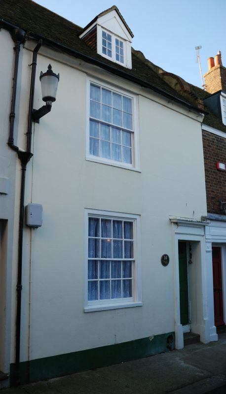
1. GRIFFIN STREET
1035
(South Side)
No 14
TR 3753 SE 2/95 1.6.49.
II GV
2.
Originally one house with No 13. Early C18. 2 storeys stuccoed. Old tiled
roof with 1 hipped dormer with easement. Shaped Dutch gable, 1 sash with glazing
bars intact. Right side doorcase having a moulded architrave, flat hood and
6 fielded panelled door, the top 2 panels cut away and glazed.
Nos l3 to 17 (consec) form a group.
Listing NGR: TR3774453171
External links are from the relevant listing authority and, where applicable, Wikidata. Wikidata IDs may be related buildings as well as this specific building. If you want to add or update a link, you will need to do so by editing the Wikidata entry.


Other nearby listed buildings
