Approximate Location Map
Large Map »
Latitude: 51.2282 / 51°13'41"N
Longitude: 1.4038 / 1°24'13"E
OS Eastings: 637739
OS Northings: 153170
OS Grid: TR377531
Mapcode National: GBR X1R.V0X
Mapcode Global: VHMDG.8DZB
Plus Code: 9F336CH3+7G
Entry Name: 15, Griffin Street
Listing Date: 1 June 1949
Grade: II
Source: Historic England
Source ID: 1252526
English Heritage Legacy ID: 177099
ID on this website: 101252526
Location: Deal, Dover, Kent, CT14
County: Kent
District: Dover
Civil Parish: Deal
Built-Up Area: Deal
Traditional County: Kent
Lieutenancy Area (Ceremonial County): Kent
Tagged with: Building
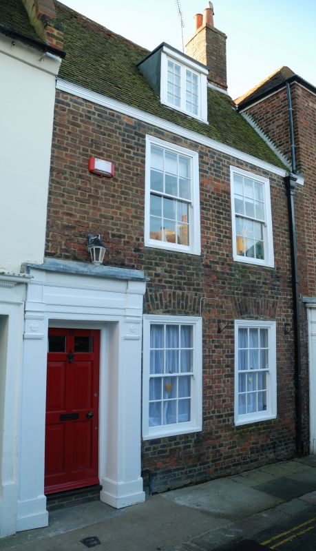
1. GRIFFIN STREET
1035
(South Side)
TR 3753 SE 2/95 No 15
1.6.49.
II GV
2.
Mid to late C18. 2 storeys and attics red brick. Tiled roof with dormer. 2
sashes in moulded architraves with glazing bars intact. Left side doorcase with
pilasters and entablature. 6 fielded panelled door with the top 2 panels cut
away and glazed. Panelled interior with fireplace and curved cupboard.
Nos l3 to 17 (consec) form a group.
Listing NGR: TR3773953170
External links are from the relevant listing authority and, where applicable, Wikidata. Wikidata IDs may be related buildings as well as this specific building. If you want to add or update a link, you will need to do so by editing the Wikidata entry.


Other nearby listed buildings
