Approximate Location Map
Large Map »
Latitude: 51.2292 / 51°13'45"N
Longitude: 1.4039 / 1°24'13"E
OS Eastings: 637741
OS Northings: 153283
OS Grid: TR377532
Mapcode National: GBR X1R.V1T
Mapcode Global: VHMDG.9C0K
Plus Code: 9F336CH3+MG
Entry Name: 10-12, North Street
Listing Date: 8 February 1974
Grade: II
Source: Historic England
Source ID: 1343713
English Heritage Legacy ID: 177230
ID on this website: 101343713
Location: Deal, Dover, Kent, CT14
County: Kent
District: Dover
Civil Parish: Deal
Built-Up Area: Deal
Traditional County: Kent
Lieutenancy Area (Ceremonial County): Kent
Tagged with: Building
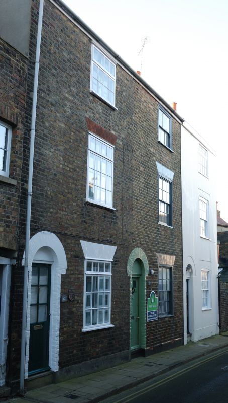
NORTH STREET
1.
1035
(South Side)
Nos 10 to 12 (consec)
TR 3753 SE 2/380
II GV
2.
An early C19 terrace. 3 storeys, yellow brick but No 12 now has a roughcast
facade. Wooden eaves cornice. 1 sash each, with most glazing bars intact.
Simple round-headed doorcases with blocked fanlights. 6 panelled doors to Nos
10 and 11 with top 2 panels cut away and glazed.
Nos 8 to 12 (consec) form a group.
Listing NGR: TR3774153283
External links are from the relevant listing authority and, where applicable, Wikidata. Wikidata IDs may be related buildings as well as this specific building. If you want to add or update a link, you will need to do so by editing the Wikidata entry.


Other nearby listed buildings
