Approximate Location Map
Large Map »
Latitude: 51.2229 / 51°13'22"N
Longitude: 1.4018 / 1°24'6"E
OS Eastings: 637629
OS Northings: 152580
OS Grid: TR376525
Mapcode National: GBR X1Y.76Z
Mapcode Global: VHMDG.7JXC
Plus Code: 9F336CF2+5P
Entry Name: 13, Queen Street
Listing Date: 8 February 1974
Grade: II
Source: Historic England
Source ID: 1069742
English Heritage Legacy ID: 177246
ID on this website: 101069742
Location: Deal, Dover, Kent, CT14
County: Kent
District: Dover
Civil Parish: Deal
Built-Up Area: Deal
Traditional County: Kent
Lieutenancy Area (Ceremonial County): Kent
Tagged with: Building
QUEEN STREET STREET
1.
1035
(South East Side)
No 13
TR 3752 NE 1/393
II
2.
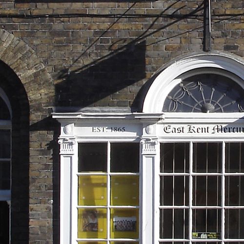
Early to Mid Cl9. 2 storeys and attics yellow brick. 2 sashes. Fine early
Cl9 shop front, like a Venetian window, having pilasters with Ionic capitals.
Tall early C19 doorcase with semi-circular fanlight, reeded ½ columns and 6 fielded
panelled door. Listed for shop front.
Listing NGR: TR3762952580
External links are from the relevant listing authority and, where applicable, Wikidata. Wikidata IDs may be related buildings as well as this specific building. If you want to add or update a link, you will need to do so by editing the Wikidata entry.


Other nearby listed buildings
