Approximate Location Map
Large Map »
Latitude: 51.2763 / 51°16'34"N
Longitude: 1.3382 / 1°20'17"E
OS Eastings: 632923
OS Northings: 158307
OS Grid: TR329583
Mapcode National: GBR X12.WPG
Mapcode Global: VHLGS.45TY
Plus Code: 9F3378GQ+G7
Entry Name: 5, Bowling Street
Listing Date: 19 May 1950
Grade: II
Source: Historic England
Source ID: 1343705
English Heritage Legacy ID: 177288
ID on this website: 101343705
Location: Sandwich, Dover, Kent, CT13
County: Kent
District: Dover
Civil Parish: Sandwich
Built-Up Area: Sandwich
Traditional County: Kent
Lieutenancy Area (Ceremonial County): Kent
Tagged with: Building
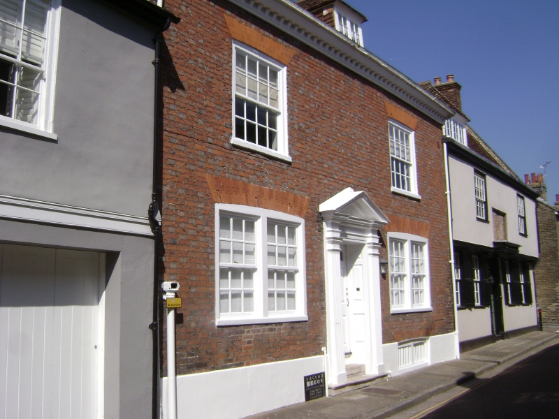
1.
5275 BOWING STREET
(West Side)
No 5
TR 3238 1/24 19.5.50.
II GV
2.
C18 fronting with probably an earlier interior. 2 storeys and attic. 2 windows.
One dormer. Red brick and grey headers. Wooden modillion eaves cornice.
Glazing bars intact. Twin windows on ground floor. Good doorway with fluted
pilasters, pediment and 6-panel moulded door.
No 1 (Water Lane House) Bowling Cottage and Nos 3 to 7 (odd) with Nos 1 to 5 (odd)
Vicarage Lane form a group.
Listing NGR: TR3291958307
External links are from the relevant listing authority and, where applicable, Wikidata. Wikidata IDs may be related buildings as well as this specific building. If you want to add or update a link, you will need to do so by editing the Wikidata entry.


Other nearby listed buildings
