Approximate Location Map
Large Map »
Latitude: 51.2756 / 51°16'32"N
Longitude: 1.3379 / 1°20'16"E
OS Eastings: 632904
OS Northings: 158233
OS Grid: TR329582
Mapcode National: GBR X12.WM3
Mapcode Global: VHLGS.46NG
Plus Code: 9F3378GQ+65
Entry Name: Delf House
Listing Date: 19 May 1950
Grade: II*
Source: Historic England
Source ID: 1069712
English Heritage Legacy ID: 177368
ID on this website: 101069712
Location: Sandwich, Dover, Kent, CT13
County: Kent
District: Dover
Civil Parish: Sandwich
Built-Up Area: Sandwich
Traditional County: Kent
Lieutenancy Area (Ceremonial County): Kent
Tagged with: House
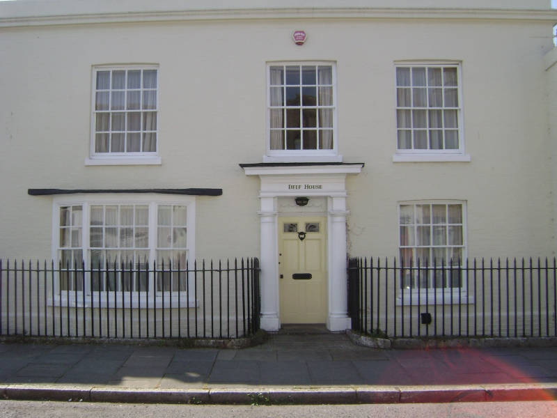
1.
5275 DELF STREET
(South-West Side)
No 21 (Delf House)
TR 3258 1/68 19.5.50.
II* GV
2.
C17 house refronted in the early C19. 2 storeys, 3 windows, painted brick.
Cemented cornice and parapet. Glazing bars intact. 3-light bay window on
ground floor. Doorway with fluted Doric columns, blocked rectangular fanlight
and 6-panel fielded door. In the space between the house and the original
railings to the street runs the stream known as the Delf.
Nos 17 to 21 (odd) form a group.
Listing NGR: TR3290058224
External links are from the relevant listing authority and, where applicable, Wikidata. Wikidata IDs may be related buildings as well as this specific building. If you want to add or update a link, you will need to do so by editing the Wikidata entry.


Other nearby listed buildings
