Approximate Location Map
Large Map »
Latitude: 51.269 / 51°16'8"N
Longitude: 1.3394 / 1°20'21"E
OS Eastings: 633040
OS Northings: 157506
OS Grid: TR330575
Mapcode National: GBR X18.9G5
Mapcode Global: VHLGS.5CFH
Plus Code: 9F33789Q+JQ
Entry Name: Chapel of St Bartholomew
Listing Date: 19 May 1950
Last Amended: 23 April 1976
Grade: I
Source: Historic England
Source ID: 1343722
English Heritage Legacy ID: 177376
Also known as: St Bartholomew's Hospital chapel
ID on this website: 101343722
Location: Sandwich, Dover, Kent, CT13
County: Kent
District: Dover
Civil Parish: Sandwich
Built-Up Area: Sandwich
Traditional County: Kent
Lieutenancy Area (Ceremonial County): Kent
Tagged with: Chapel
1.
5275 DOVER ROAD
(West Side)
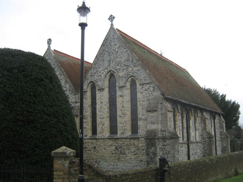
Chapel of St Bartholomew
(Formerly listed as The
Chapel, Deal Road)
TR 3357 NW 2/192A 19.5.50.
I GV
2.
An excellent example of an early English Chapel, restored and enlarged by Sir
Gilbert Scott in the C19.
Bartlemas and the complex of St Bartholomews Hospital form a group.
Listing NGR: TR3304357510
External links are from the relevant listing authority and, where applicable, Wikidata. Wikidata IDs may be related buildings as well as this specific building. If you want to add or update a link, you will need to do so by editing the Wikidata entry.


Other nearby listed buildings
