Approximate Location Map
Large Map »
Latitude: 51.2725 / 51°16'20"N
Longitude: 1.3418 / 1°20'30"E
OS Eastings: 633187
OS Northings: 157895
OS Grid: TR331578
Mapcode National: GBR X18.420
Mapcode Global: VHLGS.68PW
Plus Code: 9F3378CR+XM
Entry Name: 16 and 18, Mill Wall Place
Listing Date: 19 May 1950
Grade: II
Source: Historic England
Source ID: 1069614
English Heritage Legacy ID: 177541
ID on this website: 101069614
Location: Sandwich, Dover, Kent, CT13
County: Kent
District: Dover
Civil Parish: Sandwich
Built-Up Area: Sandwich
Traditional County: Kent
Lieutenancy Area (Ceremonial County): Kent
Tagged with: Building
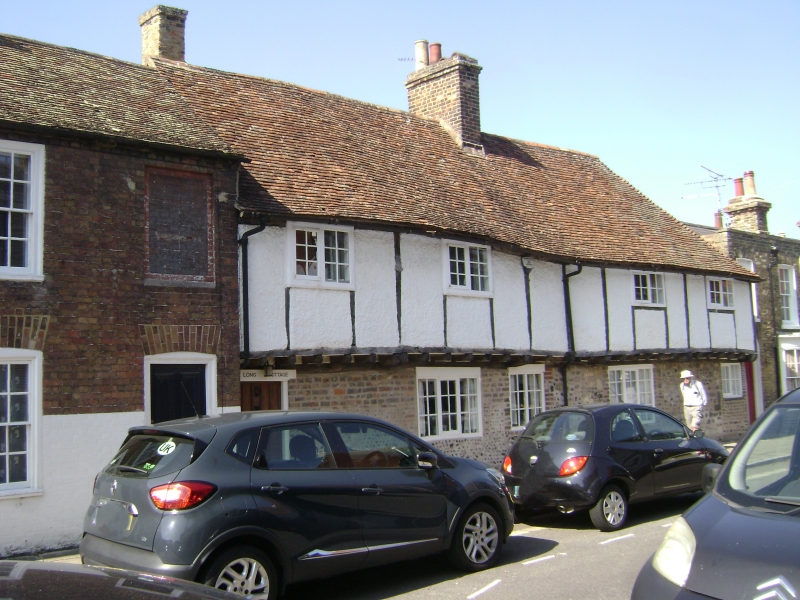
1.
5275 MlLLWALL PLACE
(West Side)
Nos 16 and 18
TR 3357 NW 2/114 19.5.50.
II GV
2.
The ground floor is a mixture of Caen stone, flint and brick and the upper floor
is jettied probably of late C16 date, half timbered and rough cast plaster. Tiled
roofs, one end hipped. All windows are casement sashes with glazing bars complete.
Modern oak front door and original shutters on ground floor.
Nos 10 to 32 (even) form a group.
Listing NGR: TR3318657896
External links are from the relevant listing authority and, where applicable, Wikidata. Wikidata IDs may be related buildings as well as this specific building. If you want to add or update a link, you will need to do so by editing the Wikidata entry.


Other nearby listed buildings
