Approximate Location Map
Large Map »
Latitude: 51.1412 / 51°8'28"N
Longitude: 1.2835 / 1°17'0"E
OS Eastings: 629775
OS Northings: 143124
OS Grid: TR297431
Mapcode National: GBR W1F.7BX
Mapcode Global: VHLHB.6KCZ
Plus Code: 9F3347RM+F9
Entry Name: Crabble Court
Listing Date: 30 June 1949
Grade: II
Source: Historic England
Source ID: 1363226
English Heritage Legacy ID: 177803
ID on this website: 101363226
Location: Crabble, Dover, Kent, CT17
County: Kent
District: Dover
Civil Parish: River
Built-Up Area: Dover
Traditional County: Kent
Lieutenancy Area (Ceremonial County): Kent
Tagged with: Building
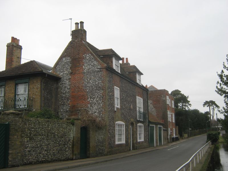
LOWER ROAD, CRABBLE
1. (South West Side)
1050
Crabble Court
TR 2943 5/54 30.6.49.
II GV
2.
Late C18. 3 storeys red brick, partly flint-faced on left side elevation.
Parapet. 3 sashes with glazing bars intact. 2 curved bays through all 3
storeys. Round-headed doorcase with semi-circular fanlight and 6 panelled
door.
Forms a group with The Old Vicarage.
Listing NGR: TR2977543124
External links are from the relevant listing authority and, where applicable, Wikidata. Wikidata IDs may be related buildings as well as this specific building. If you want to add or update a link, you will need to do so by editing the Wikidata entry.


Other nearby listed buildings
